Wednesday, March 21, 2018

The latest on Winter Storm Toby

I'm sure all my students are patiently waiting for this update wondering if they are going to have snow day #7 tomorrow. Well I will give you all the information I have found and then you decide.


First the timing: The snow may start around 11:00 am in our area but this will be light snow and will not stick to the road at the beginning. By 7pm the snow will start to get heavier and the steady snow will continue through early Thursday morning. I am now hearing that the snow may linger until 7 am Thursday.

Winds: we will be getting higher than usual winds in our area. so by now we all know that with heavy wet snow and high winds there is the chance of power outages. I will be prepared with flashlights, candles, lots of blankets, and a fully charged cell phone.

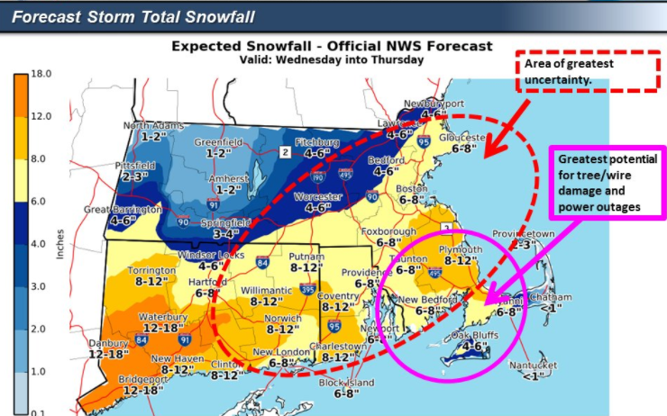
Snow amounts: Here are some of the maps that I found this morning.


according to these maps wbz, fox, and NBC all predict this area in the 8-12 inch range and the rest predict up to 8 inches.  Even 6 inches of this wet heavy snow can cause problems.


Tuesday, March 20, 2018

Toby is our next nor'easter

Winter storm Toby is due to arrive here Wednesday morning. There has been a little change in the track of the storm. Toby has gone a little further south so amounts are a little bit lower. We still need to be concerned with the winds and the fact that this snow is supposed to be heavy wet snow. Be prepared for more power outages.
The snow will start to fall some time in the late morning, but will be light and should not accumulate much during the day. According to everything I have read today the heaviest snow should fall between 5pm Wednesday and 5am Thursday. Below is a map from the national weather service with expected times of the snow arriving.


The winter storm warning has been expanded to include the cape.


Here are the latest snowfall maps with the lower totals


I will be back tomorrow morning with another update unless things change dramatically in the next 6 hours, if they do then I will post again tonight.


Snow Amounts on the Rise

Good morning everyone.  I know all my students, especially the seniors, want to know how much snow we are going to get so here are a few maps I got this morning.


The snow should start falling during the late morning, but should stay light until late afternoon. The afternoon commute may be a slow one. The snow will continue to fall into the early Thursday morning. I will post another update this afternoon.

Monday, March 19, 2018

Wednesday Snow

So many people have stopped by my office today asking about snow on Wednesday....yes we are getting more. The first snowfall total maps are out and it looks like we will all be shoveling again.


These are the first maps I found so I am sure they will change a little as the storm gets closer. Stay tuned for more details.

Here we go AGAIN

Well if you wanted more snow looks like you will get your wish. There is another nor'easter headed our way this week.


The computer models are now showing this storm coming closer to the shore which means we get snow. How much snow is still to be determined.


All I know is that we are in the area of moderate probability of snow. I will continue to follow this storm and report back when I know more. I'm sure my seniors will be following this to see if they will be getting snow day #7 of the year. I hope not, I'm good with our last day of school being 
June 21st. I want the warm weather so I can do things outside without freezing.


Tuesday, March 13, 2018

Not another one

Looking ahead I am watching the chance of another nor'easter next week. There is the potential for a storm Tuesday/Wednesday. Check back here in a few days to get more details. Maybe we will get lucky and this one will go out to sea

Monday, March 12, 2018

Snow Day

You may have heard that it is going to snow tomorrow, and snow and snow and snow. The white stuff should pile up to over a foot in quite a few areas. The snow should start falling around midnight and and will stop late Tuesday night. The wind will be strong causing blizzard conditions in some parts or eastern Massachusetts,


Below are all the new snow maps I could find. Stay home tomorrow and enjoy the day off.


Afternoon Update

Not too much has changed since my last post. The storm is still set to arrive around midnight and last all day Tuesday into the night. A few of the snow total maps have increased a little so I will post them tonight. I will watch all the 6 o'clock reports and then post the latest maps here.
Be back around 7pm

Changes

There have been a few changes this morning. The snow totals have increased yet again.


I will post an update again some time this afternoon.

Sunday, March 11, 2018

Skyar is headed our way

The more I read about this storm, the more I see the word "blizzard"  Blizzard means winds of a minimum of 35 mph along with blowing or falling snow causing visibility of less than 1/4 of a mile and all these conditions must exist for a minimum of 3 hours. This map below is from the national weather service and you can see the red circular area where they expect blizzard conditions


I found a new source for snow total maps - Mill City weather on facebook. They are out of Lowell Massachusetts.


I posted snow total maps from channel 7 and the weather channel in my last post but those amounts have gone up this evening so here are the new maps.


The next two maps are from channel 4 and channel 5. These maps appeared online late this afternoon but while watching their evening news a few minutes I Noticed the amounts a little lower. channel 4 had us in 6-12+ and channel 5 had 8-12+ The amounts will continue to go up and down for the next 24 hours and I will continue to copy and post them here. 


Not only the large snow amounts but also the winds from this storm have me concerned. I will keep my fingers crossed that my friends (and myself) do not lose power. (again)


snow lovers delight

If you like snow then you will be happy to hear that the amounts of snow for Tuesday are going up. The weather channel channel app has amounts for Monday night and then additional amounts for Tuesday that total 13-20 inches! The storm is still over 24 hours away so this could all change but here are the latest snow total maps.


Channel 4 had a map out this morning that had us in the 6-12 inch range but this map came out at noon time and we are not 12+ inches


Channel 25 put out their first map and they are being a little conservative compared to other stations.


I will post another update after all the 6pm news broadcasts. 


Monday night into Tuesday

This is a short update just to post a couple of snow total maps that came out this morning. If you don't like snow then you will not like this update. Right now the thinking is that this storm will bring at least six inches of snow our way. The snow starts late Monday night and continues through the night Tuesday.

I have channel 4 with 6-9 inches then channel 7 has 6-12 inches and finally weather.com with 8-12


Saturday, March 10, 2018

Nor'Easter number 3 for the month

Here we go again. Another nor'easter is heading our way late Monday night and all day Thursday. at this time we don't have a handle on what the track of this storm will be. I have been reading everything I can online today and believe me there has been a lot written and they all say something different. At first the storm was supposed to go out to see giving us just a light amount of snow but today the computer models moved the track a little closer to us which means a little more snow.
I found this on twitter
No one wants to put out a snow total map this early but I did find a few maps


WBZ and the National weather service put out these maps showing the confidence in eastern Mass getting snow. 
Below is a screen shot from the phone of the weather app. These amounts seem to be on the high side.


Below is the map that weather.com had for snow totals. ON past maps that light purple color has represented 5-8 inches.


I will search all my websites tomorrow and post whatever I find. As of today my last day of school is Tuesday June 19th. I don't want to go any later into June so I am not looking for another snow day but I'm sure my seniors are saying "come on snow day". Stay tuned for more snow day details