Sunday, February 21, 2016

Too Warm for Snow

We have some precipitation coming our way this week but that will be in the form of mostly rain due to the warm temperatures.
Clouds will move in later this afternoon and some rain will begin this evening. As we get closer to midnight the temperatures will begin to drop and the rain may mix with snow. If the temperatures drop enough we could get up to an inch of snow. This will be in the southern part of the state.
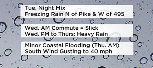
The next storm moves in Late Tuesday night and continues all day Wednesday. Temperatures will be too warm for snow so this will be a rain storm.


If anything changes I will post again

Thursday, February 18, 2016

Watching a possible storm for next week

The temperatures are mild for the middle of February. This weekend's temp will be around 50 degrees, but the weather will be changing next week. I am watching a possible storm for the middle of the week. Which form of precipitation we get (ice snow rain) depends on the exact track of the storm and the storm track can't be figured out this early. Below is the post that first alerted me to this possible storm


Now we just have to wait a few more days to see what actually develops.


The first reports from the weather channel are that the storm will track to the east and that brings in warmer temperatures


I will continue to keep you updated.


Monday, February 15, 2016

Olympia

If a winter storm is going to affect at least 2 million people or 400,000 square kilometers then the storm gets a name. The latest to be named is Olympia which is scheduled to hit our area late this afternoon. The storm will start out as snow and then change to ice and eventually all rain.


We should only get an inch or two before the snow changes to ice for a short time and then quickly we get all rain.


Once the rain starts it will become heavy at times, Tuesday will be a rainy and windy day for those of us here in eastern Massachusetts. Hard to believe that yesterday we were freezing with temperatures below zero and tomorrow temperatures will be in the 50s.


Our next chance at seeing some snow isn't until Friday February 26th. That is over a week away.


Sunday, February 14, 2016

Monday night snow

Happy Vacation everyone! I love being on school vacation because I don't have to wake up to an alarm. This vacation I may be able to get out and do things because the temperatures will be on the mild side. There is a system coming this way Monday night. This storm will start as snow then change to a wintry mix and late Tuesday morning it will be raining everywhere.

Thursday, February 11, 2016

Here Comes the Cold

You will need to layer up if you go out this weekend. High Temperatures will not get out of the teens and low temps will be below zero. BUNDLE UP! There is a storm traveling our way and I expect it to arrive some time late Monday. We will get some snow, ice and rain. A wonderful wintry mix.
Snow will move in later in the day and then change to a mix by dark.


I'll blog again when I know more.

Sunday, February 7, 2016

Snow day Again

I am sure that many of you reading this have already heard that you have a snow day tomorrow. #2 for me. I wonder if this winter will have as many snow days as last year. I believe I had 6 days last year.
The latest updates on the storm coming tomorrow morning is that this storm, named Mars, will hit us a little harder than first expected.  Here are some facts about this storm


  • A winter storm warning is in effect from 4am Monday until 7am Tuesday.
  • Winds will average 20 mph with guests up to 40 mph (may cause power outages)
  • Snow will begin in the early morning hours (2 am) along the south coast spreading Northward so that the snow should be in Boston by 8am. 
  • Snow fall will be heavy after 8am, please use caution if you must drive
  • a widespread area will get 8-12 inches of snow
Here are the latest snow map totals that I have found.


Unless something changes this will be my last post tonight. Enjoy the snow 


Update coming soon

Since posting my last blog I have noticed a few sources are increasing their amounts like channel 5 shown below. The map on the left is from this morning and the map on the right is from 3:00 this afternoon.


I will look for all the updates and post again this evening.

Ready for some more snow?

I have spent the past two hours ready everything I can about the snow coming our way. There is the potential for several inches especially if we get the ocean enhanced effect. This storm is coming in a little bit later than our last storm. The snow will start Monday morning around 5am along the south coast and then continue to move northward. MEMA is warning that this storm may bring some strong winds.


Remember that a Blizzard does not mean we are getting a lot of snow. Below are the conditions needed for a Blizzard.


Be prepared for more power outages due to high winds. Below are the expected winds gusts from this storm.


I have posted snow total maps from several different sources below. If anything changes I will post an update later today.


And the latest map to hit the internet is from the National Weather Service. They have increased their amount in the past hour.


Saturday, February 6, 2016

Snowy week ahead

There could be up to three chances for snow this week. Monday, Tuesday and there is a possibility for more on Friday.  The storms have the potential to be big but only if they track close enough to the coast. I'll have another update for you tomorrow.


Friday, February 5, 2016

Winter has Arrived

I got my first snow day of the year, Yippee! Now I turn my attention to the next storm. The weather pattern is about to change. We have a couple of storms coming up the coast. The first may arrive Monday


How much snow we get depends on the path of the storm and how close it is to the coast. The as soon as that storm  moves out another moves right in.


Active storm pattern is here, The question I have is How many more snow days do we get?

I will continue to read all about these storms and keep you updated.

Thursday, February 4, 2016

Bring it on!

Everyone that reads this blog is well aware of how much I love snow, especially when the snow gives me a snow day. Well Friday morning's snow storm may give me my first snow day this year. The meteorologists are reporting that we will have at least 6 inches of snow and that the snow will start in the predawn hours (around 5am) If this does indeed happen then traveling could be dangerous


This storm caught me by surprise because yesterday I tweeted it was no big deal. Boy has that changed. I found this tweet from a Boston meteorologist


Below are the latest updated maps with snow fall amounts.


Amounts going Up

Did you hear.....We have snow in the forecast for tomorrow morning. Yesterday all the reports I read had 2 or 3 inches but that continues to climb. This morning I found these maps


At noon time today Channel 7 decided to increase their amounts to the map below


The rain will continue throughout the night and then change over to snow in the early morning hours around 4:30/5:00

This time could mean a messy morning commute. I will keep an eye on this and update late tonight.
Will this storm give us our first snow day of the school year????


Wednesday, February 3, 2016

A little bit of Snow Friday Morning

I just found out that it will be cold enough for snow Friday morning so we may get a couple of inches in our area. Nothing big so don't get too excited. Below are a couple of maps. One from the national weather service and one from a local tv station


after this snow I will concentrate on the chance for next week that I talked about in my blog earlier today.


The search for Snow

Every day I go on my favorite weather websites (and there are LOTS of them) looking for any snow in our forecast. I am happy to report I found some. There is a chance for snow next Tuesday into Wednesday. Weather.com is reporting only a few inches but there is the potential for more. Two models, The EURO and GFS are showing snow!  Below is a quote from Southern New England Severe Weather alerts.


Now we wait and see if this really happens.

Monday, February 1, 2016

Warm Week

The temperatures this week will be well above normal for this time of year. Temps will be right around 50 degrees everyday. The only storm we have coming our way is all rain on Wednesday. So depressing for us snow lovers.