I will keep you posted hear on the weather blog
Thursday, December 28, 2017
Snow Thursday January 4th
I hope everyone had a great Christmas. I was so excited that we got a couple of inches of snow Christmas morning. The next chance of snow is one week from today. I will have to keep an eye on this one. According to Matt Noyes on NECN this storm has the potential to be a significant one
Friday, December 15, 2017
A little more snow
I don't want anyone to get caught off guard tonight. We will be getting more snow! Nothing major but when you are heading out to do some more Christmas shopping after work today you may encounter up to an inch of snow. Just enough to make traffic a little crazy. Be careful.
As of today it appears we may have a chance for snow on Christmas. That will be pretty.
As of today it appears we may have a chance for snow on Christmas. That will be pretty.
Monday, December 11, 2017
Tuesday
I hope everyone enjoyed the snow this past weekend. There is talk of a little more snow on Tuesday but I think it will be too warm here for snow so we should see a quick turn over to rain and unfortunately that will wash away most of the snow we got Saturday.
Friday, December 8, 2017
Benji
The snow storm for Saturday has been named. Storm Benji is due to arrive Saturday afternoon and continue through the night. The weather channel is predicting 5-8 inches.


Seems like every time I check the internet for updates on this storm, the snow amounts go up a little. I hope the roads arent too bad because I have Christmas shopping to do during the day and I want to attend the first hockey game of the season for Norton Saturday night.
Saturday Update
Here are a few more maps for snow totals Saturday afternoon into the night. WBZ changed their amounts by adding an inch to the totals they had last night. All the other snow maps remain the same as I posted yesterday.


Thursday, December 7, 2017
more than a Dusting
I hope you are ready for some snow. What was supposed to be a dusting may be a little more than that. Here are all the snow maps that I can find


The snow should start Saturday afternoon but with the sun warming the pavement the snow will have a hard time sticking except on grasssy surfaces. Once the sun goes down then the snow will begin to accumulate on the roads.
After this storm we have another chance of snow next Wednesday. I'll be keeping an eye on that one
Wednesday, December 6, 2017
Just a Dusting
Are you ready to see a little of the white stuff falling from the sky? You may get your chance this weekend. There is a chance we will get some light flurries on both Saturday and Sunday. Right now it looks like the low pressure will stay far enough off shore so we won't get any plowable snow amounts. If anything changes I will let you know.
Monday, December 4, 2017
is it time for snow yet?
Hello all my fellow snow lovers. I spent the last three days in sunny warm Walt Disney World and then I come home to hear there is a possibility of snow this weekend. After enjoying all the Christmas decorations at the Disney parks, I am ready for the cold weather associated with Christmas here in the northeast. I will do some investigating about this and blog again either Tuesday or Wednesday.
Monday, September 18, 2017
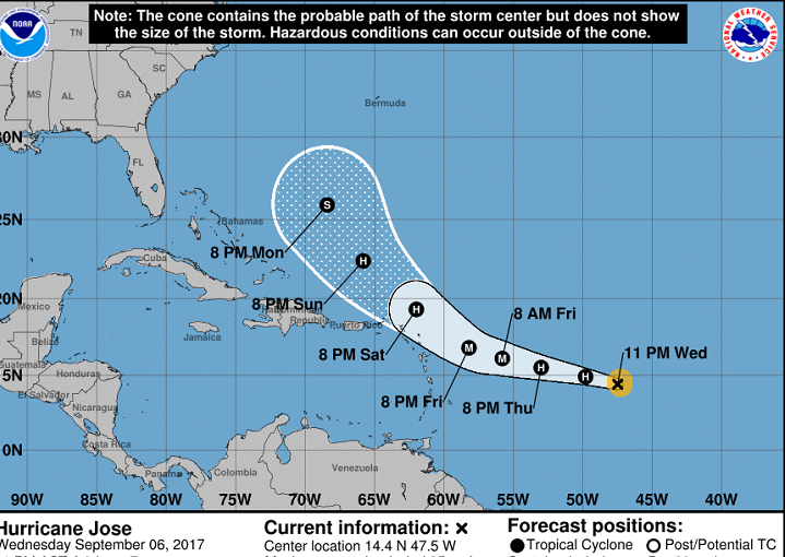
Hurricane Jose
Jose is headed north to Massachusetts but is expected to take a turn to the east before reaching us. The storm will also weaken before reaching us because of the colder water temperatures in the north. Even though we are not getting a direct hit from this storm we will feel some if its effects. southeastern mass is expected to get over an inch of rain and some winds of 35 mph. There is a chance of some power outages so be sure to charge all your electronic devices. If anything changes I will blog about it.
Friday, September 8, 2017
Irma
Another hurricane is headed towards The US. Hurricane Irma is a category 4 hurricane headed towards Florida. Most of Southern Florida has been evacuated and schools are closed until further notice. The storm is scheduled to hit Florida sometime early Sunday with winds estimated to be 150 mph. I hope my family and friends (along with everyone else down there) stay safe.

I heard the governor of Florida say "We can rebuild your house but we can't rebuild your life" He is asking everyone to evacuate to a safe area. Most people are listening to all the warnings so highways have been packed. This is one road Thursday afternoon

Irma is expected to be a category 4 when it hits southern Florida and then weaken as it travels inward.


Before hitting Florida Irma destroyed so many small islands and those Islands are getting a one two punch as Hurricane Jose is headed their way

Here in Massachusetts we wait to hear if we will get any remnants from these storms. I'll keep you posted

I heard the governor of Florida say "We can rebuild your house but we can't rebuild your life" He is asking everyone to evacuate to a safe area. Most people are listening to all the warnings so highways have been packed. This is one road Thursday afternoon

Irma is expected to be a category 4 when it hits southern Florida and then weaken as it travels inward.


Before hitting Florida Irma destroyed so many small islands and those Islands are getting a one two punch as Hurricane Jose is headed their way
Here in Massachusetts we wait to hear if we will get any remnants from these storms. I'll keep you posted
Friday, August 25, 2017
Hurricane Season
The time now is both Hurricane season and back to school season. I can still remember a year when we had a "hurricane day" and had to postpone the opening day of school.
Today all eyes are on Texas as hurricane Harvey hits. Hoping that everyone stays safe.
I just want to make sure New Englanders don't miss a potential storm coming our way next week. There is a storm near Florida that has not been named yet, but may become Irma.
Eric Fisher from channel 4 tweeted the following.

Thursday, March 30, 2017
Spring Snow
I know the calendar says we are in the spring season, but mother nature isn't finished with winter. We have more snow in the forecast for Friday into Saturday

I will continue to read reports and make sure this doesn't turn into anything more.

I will continue to read reports and make sure this doesn't turn into anything more.
Monday, March 13, 2017
March Snow Storm - the latest
This is the headline on weather.com

This is supposed to be a powerful storm but the storm seems to have taken a slight turn to the west which means we now have a rain/snow line. We will have to keep track of where this storm crosses over the state. right now it appears that the snow amounts will be lower in southeastern mass due to rain. These are the latest snow total maps.


The storm will be starting right around the morning rush hour and the snow will come down heavy for several hours. 2 inches per hour


Everyone be safe and have fun in the snow,
Sunday, March 12, 2017
Blizzard Watch
I m posting again because there has been an update. Most of the eastern part of the state is now in a blizzard watch.

These are the storm headlines

The timeline is as follows...

A few TV stations changed their snow total maps so here they are


My next post will be sometime Monday afternoon. Enjoy the snow everyone

These are the storm headlines
The timeline is as follows...

A few TV stations changed their snow total maps so here they are


My next post will be sometime Monday afternoon. Enjoy the snow everyone
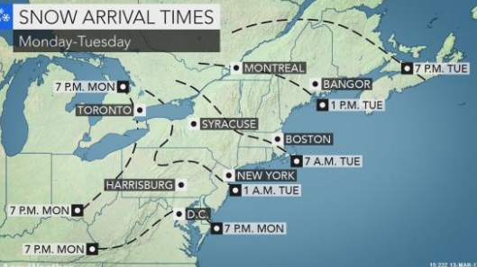
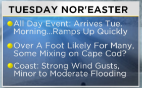
Sunday update
I hope everyone is ready for a large snowfall. Every meteorologist seems to be predicting the same amount for us. They are all on board for 12-18 inches of snow.
The snow will start to fall just before the morning commute and then continue all day into the night.

The low is traveling a little faster than first expected so the snow should stop over night Tuesday not linger into the day Wednesday, but then there is the big clean up for Wednesday. There will be times on Tuesday that the snow is falling at 2 inches per hour.
The other problem will be the wind. You should prepare for some power outages.

There is a chance for blizzard conditions. The National Weather Service defines a blizzard as a storm which contains large amounts of snow OR blowing snow, with winds in excess of 35 mph and visibility of less than 1/4 mile. These conditions have to exist for a minimum of 3 straight hours to be called a blizzard.
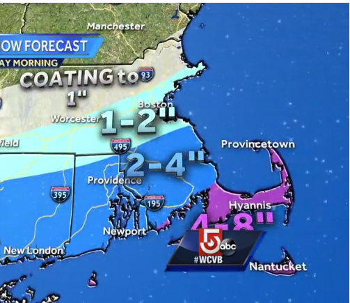
Here are all the different snow total maps that I found
 this one from CBS Boston
 this one from channel 5 in Boston


If anything changes I will post an update.
Enjoy your snow day
The snow will start to fall just before the morning commute and then continue all day into the night.

The low is traveling a little faster than first expected so the snow should stop over night Tuesday not linger into the day Wednesday, but then there is the big clean up for Wednesday. There will be times on Tuesday that the snow is falling at 2 inches per hour.
The other problem will be the wind. You should prepare for some power outages.

There is a chance for blizzard conditions. The National Weather Service defines a blizzard as a storm which contains large amounts of snow OR blowing snow, with winds in excess of 35 mph and visibility of less than 1/4 mile. These conditions have to exist for a minimum of 3 straight hours to be called a blizzard.
Here are all the different snow total maps that I found
 this one from CBS Boston
 this one from channel 5 in Boston


If anything changes I will post an update.
Enjoy your snow day
Saturday, March 11, 2017
Snow storm Stella
Stella is headed our way Tuesday (very early morning) through Wednesday late morning. The exact track is not certain yet but we are sure to get some snow. most forecasters are saying we should expect a foot
.
The amount we get depends on where that powerful Low travels. a west track means a rain/snow line in southern mass, and east track means smaller amounts of snow for everyone because the heavy snow stays out to sea and a track through the middle of the west and east track means over a foot of snow. I should know more by Sunday afternoon.
A blizzard warning has already been posted for parts of our state by the national weather service.

Weather.com hasn't posted amounts but they did post this map showing we should expect heavy snow.

I will post an update tomorrow afternoon.
.

The amount we get depends on where that powerful Low travels. a west track means a rain/snow line in southern mass, and east track means smaller amounts of snow for everyone because the heavy snow stays out to sea and a track through the middle of the west and east track means over a foot of snow. I should know more by Sunday afternoon.
A blizzard warning has already been posted for parts of our state by the national weather service.

Weather.com hasn't posted amounts but they did post this map showing we should expect heavy snow.

I will post an update tomorrow afternoon.
Friday, March 10, 2017
Pi-Day Nor'easter
All my attention is on the snowstorm heading our way, Tuesday (3-14). The storm is still days away so as all the forecasters say, we can't tell the exact path of the storm yet. It is too early to tell. I will say that weather.com has increased their amounts from what they posted yesterday


yesterday they had 5 - 8 during the day and now they have 8-12 during the day
yesterday they had 3-5 falling at night and now they have 5 - 8 falling at night.
Accuweather also feels that we will get a substantial storm with the chance of blizzard conditions.

There are two storms, one coming from the south and one coming from the west, the two storms are expected to join and give us a snowstorm with plowable amounts.
I will write another update tomorrow.
Thursday, March 9, 2017
3 chances of snow
Here is the latest. Friday's snow looks to be only about 3 or 4 inches but most of this is coming during the morning commute.
The snow predicted for Sunday looks to be going south so we may not see any snow at all
Tuesday may be a problem.

Early predictions from the weather channel show 5-8 inches falling during the day then an additional 3 - 5 inches falling Tuesday night.
I will continue to keep my readers updated when changes in the forecast occur.
March snow

The picture above is the headline from weather.com
We have 3 chance for snow but right now I will focus on Friday's snow. Yes we have snow arriving tomorrow morning. The snow should start around 6am with anywhere from 2 to 6 inches. Here are all the snow total maps I could find.


Norton is pretty close to the top of the 3-6 inch line

Subscribe to:
Posts (Atom)