Friday, January 28, 2022

Major Snow Storm

 We are less then 24 hours away from a major snow storm. Kenon, will arrive in our area shortly after midnight.


along with the snow there will be strong winds which unfortunately means power outages. That could be dangerous with such cold temperatures this weekend. Thankfully there is a warm up coming next week.

This morning a few people have increased their snow amounts. I have been hearing 30-36 inches possible in some spots. Here are all the latest snow total maps. If anything changes I will post again after the 11pm news.


Thursday, January 27, 2022

Snow storm Kenon

 Our storm has a name - Kenon

The snow should arrive shortly after midnight and last all day Saturday. In addition to the snow there will be strong winds so be prepared for power outages. 

Here are all the snow total maps I found from the 6:00 news reports. I will update again tomorrow morning 


Still a foot of snow

 I don’t have any changes to report this morning. Most weather reports are using the same snow total maps as last night. There will be light snow flurries on Friday but the storm is not arriving until after midnight and lasting all day Saturday. Here is everything I found this morning. 


Wednesday, January 26, 2022

Snow total maps

 I have heard from several different weather outlets that the storm may go a little more to the east. That means the snow totals would shift east as well. 

Here are the latest snow total maps for today. I believe these may change by the end of the day Thursday so you know I will post again tomorrow 


NOR’easter

 This is what I have been able to find this afternoon. Everyone is still saying over a foot of snow 


This storm will bring lots of wind so have the generators ready. 

I will post again after I get the 11:00 pm update. 


Nor’easter headed our way

 I have found two snow total maps so far. I am sure there will be more this afternoon so I will post again some time tonight. 

This is what I have found so far…


Everything I have read and listened to has mentioned at least a foot of  snow and possible blizzard conditions which means lots of wind. Make sure all devices are charged and get the snow blower ready! 


Tuesday, January 25, 2022

Nor'easter this weekend

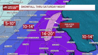
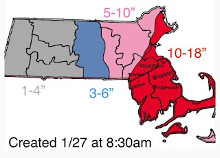
Looks like we have a storm that will travel up the east coast which equals a Nor'easter. This storm is expected to arrive some time Friday night and continue all day Saturday. It is still too early to know the exact track so no one has snow total maps out yet. The weather channel does have some early predictions though


Everything I have read this morning is stating the potential is there for over a foot of snow.

Here is a quote from Accuweather.com

There is every indication that a storm will develop and strengthen off the southern Atlantic coast late this week. The storm could intensify enough from Friday to Saturday to be classified as a bomb cyclone as it moves northward toward New England. A bomb cyclone, or bombogenesis, occurs when the central pressure of a storm crashes by 0.71 of an inch (24 millibars) or greater within 24 hours. When the pressure plummets, winds rush in toward the center of the storm at a faster pace. The winds can carry a great deal of moisture with them and unleash that in the form of copious amounts of precipitation. If the air is cold enough, heavy snow and blizzard conditions can unfold.

and this is a quote from NBC weather:

We have the potential for a major nor’easter sometime Friday night into Saturday.   The track and timing are still to be determined, with still a low chance it could miss us.  However, some key indicators hint that we will see at least something between Friday night through Saturday night.  In fact, our exclusive NBC forecast model has a high POP for the eastern half of New England on Saturday.  Several inches of snow is possible in Boston and across eastern New England.  If the storm tracks in the right way, we won’t just have over half a foot to a foot of snow, but also damaging winds and coastal flooding. 

I will continue to research this storm and post another update tomorrow morning.


Stay tuned.....


Sunday, January 23, 2022

This week snow chances

A look at the chances for snow this week. 

 We will get a few flurries tonight 

Then there is a chance of a little more snow on Tuesday

The best chance for measurable snow is Friday night into Saturday. I’ll be keeping a eye on this storm and post an update later in the week. 

Wednesday, January 19, 2022

Thursday snow

 We are not expecting a lot of snow but it comes at a bad time. The snow will start to fall around 5am making your drive to school and work a little slippery. The snow should not accumulate more than 2 inches. I will continue to watch the possible snow for this weekend. 

Sunday, January 16, 2022

Wind storm

 Get those devices charged. The storm coming in tonight will start as snow but quickly change to rain. With this rain comes the wind and lots of it. Be prepared for a possible power outage. 


Let’s hope the next storm is all snow!