Friday, February 28, 2014
Not as Big
If you were hoping the Monday storm would go out to sea, you may get your wish. There is an artic front coming down from Canada on Sunday and that front may be strong enough to push the snow storm south of us. If that happens we may only get 2 or 3 inches. I will continue to keep you posted.
Thursday, February 27, 2014
Significant Storm heading our way
All the meteorologists now agree, the moisture coming our way Monday, will be all snow and possible up to a foot of snow. This is the first snow amount map I could find. Lets see how much those amounts change as the storm gets closer.

More Snow on the way
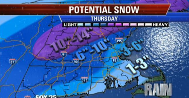
I thought I was done with snow until I heard there is a chance for another significant storm next week. As soon as I heard the news I got all excited again, started reading every weather report I could find, and now writing about this storm on my blog. Below is the forecast according to NOAA. Look at all the snow flakes.

Below are excerpts from the channel 4 weather blog and the channel 7 weather blog. Now we wait and see what really happens as this storm gets closer. You know I will probably blog about this storm at least once each day from now until Monday.


Stay tuned....
Below are excerpts from the channel 4 weather blog and the channel 7 weather blog. Now we wait and see what really happens as this storm gets closer. You know I will probably blog about this storm at least once each day from now until Monday.
Stay tuned....
Tuesday, February 25, 2014
Ready for Spring?
Are you ready for some warm spring weather? Too bad, the cold weather is sticking around a little longer and to make it even more exciting there is a potential significant snow storm coming Sunday night into Monday morning. Love that timing. The only problem is that the storm is 6 days away and a lot can happen during that time.
Even though I am talking about snow you can tell from the countdown below that Spring is not far away.

We go from my spring countdown to this 7 day forecast with lots of snow.

Even though I am talking about snow you can tell from the countdown below that Spring is not far away.
We go from my spring countdown to this 7 day forecast with lots of snow.
Monday, February 24, 2014
Little snow amounts Wednesday
If you do not like snow then I have good news for you. There is snow headed this way for Wednesday, but the jet stream is going to take the storm out to sea. We will only be on the edge of the storm so we get an inch maybe 2.

Sunday, February 23, 2014
Wednesday snow
Here we go again...snow is on the way. There is a coating to an inch expected over night and then there is the chance for more on Wednesday. Wednesday's storm is not set in stone yet because there is a chance the storm could go out to sea. Right now the computer models favor the storm coming close enough to give us some snow, maybe 3-6 inches and the snow may start some time in the late morning. I will be able to tell you more as the storm gets closer so stay tuned.

Saturday, February 22, 2014
Back to school weather
School vacation is almost over. As you can see by the 7-day forecast on the right there are two chances for snow this week. Wednesday and Saturday. Wonder if winter will ever end?
Monday, February 17, 2014
Just a few inches tomorrow
If you love lots of snow this forecast will not make you happy. We are getting more snow tomorrow but only a couple of inches.


 The snow should start to fall in the very late morning hours or the early afternoon. The snow may be heavy but should not last too long.
Then we may have a warm up and some of this white stuff may begin to melt away.
Then we may have a warm up and some of this white stuff may begin to melt away.
Saturday, February 15, 2014
Tuesday Snow
Since this storm is just about over, now is the time to think about the next snow storm. Yes there is another right around the corner. Tuesday is when we are due to get more plowable snow. I promise to keep you updated on when it will arrive and just how much snow is coming.
Time to stay in
I hope you don't have plans to go anywhere tonight. The track of today's storm has gotten a little closer to us so we are going to get a lot of snow. The snow will start late this afternoon/early evening. By 7pm the snow should be coming down steady. The closer you live to the coast the higher the wind gusts will be and that is why there is a blizzard warning in place for coastal areas. Below are all the current snow total maps.


Friday, February 14, 2014
Here is the latest for Saturday's storm
I hope you don't have plans to travel to the cape on Saturday like I do. I will have to cancel that trip due to the storm coming. There is a blizzard watch for the cape for now through Sunday morning.Below are all the maps I could find with snow totals. This storm is supposed to start during Saturday late afternoon/early evening.


weekend storm may disrupt vacation plans
Saturday is the start to school vacation and Saturday is also the day that our next snow storm arrives. If anyone has a flight heading out late Saturday, you may have some issues. Be sure to check with your airline. According to accuweather.com this storm may cause blizzard conditions in some areas.
This is the headline on their web site.


This is the headline on their web site.
Snow is supposed to arrive late Saturday afternoon and continue through the night bringing several inches of snow into the area.
6-12 inches for the cape and southeastern Mass.
I wonder when we will see Spring. This winter has just been one snow fall after another. Will they ever stop? I am a snow lover, but even I have had enough.
Saturday snow storm
Here comes some more. This winter has been an unending snowstorm, we have storm after storm after storm. The next one is due to arrive Saturday and Saturday night. A couple of stations have given a snow total so those are posted below. I will keep an eye on this and post more later today.


Thursday, February 13, 2014
The snow keeps coming
Did you know there is more snow in the immediate future? A little light snow is expected tomorrow morning and then there is another snow storm that is being watched for Saturday. That snow could give us a few more inches.

Snow Day #4
Hope everyone is enjoying their snow day. This was #4 for Norton. The snow will soon be changing over to sleet and then rain. Get ready for some heavy rain and maybe some flooding. Lets just hope the wet snow doesn't weigh too much and take down some power lines. I do not want to lose power.


Wednesday, February 12, 2014
this storm is driving me crazy
I have read several weather reports and listened to a few weather videos. Most people are thinking this storm will now cross so far inland that we will be getting enough warm air for rain. That means lower snow amounts but every meteorologist still says there is a chance the storm can turn and that would change all the amounts. I'll be up until midnight tonight checking forecasts and updating this blog.


looks like there will be school
I just got an update and if you were looking forward to a snow day, I have bad news. Storm is projected to move further to the west leaving us on the warm side which means more rain than snow.

A little bit of everything
Are you ready? Our next storm is 24 hours away. Everywhere will start out as snow tomorrow morning sometime between 7 and 8 am. then we are supposed to change over to freezing rain, sleet, and then rain. Sounds like a mess to me. As you can see from the maps below, not everyone agrees on how much snow for this area. Channel 4 says 3-6, NECN says 6 inches and channel 5 has 4-8 inches. I'll check all the maps at noon time and update my blog this afternoon.


If the amount below really happen, 4-8, could mean another snow day.
Tuesday, February 11, 2014
Update on Thursday Storm
Here is the latest that I have on Thursday's storm. I have read dozens of weather reports and weather blogs in the past hour. At this time most reports state that the storm is coming closer to us which means more rain than snow for our area. Heavy rain from what I have read.

There is a winter storm watch for our area. Around 7am everyone will start off with snow, but our area will change over to rain leaving us with a small amount of snow. Below are a few snow amount maps that I found.


There is a winter storm watch for our area. Around 7am everyone will start off with snow, but our area will change over to rain leaving us with a small amount of snow. Below are a few snow amount maps that I found.
With this forecast, I doubt that there will be a snow day. I should add in that every report I read also stated that this storm may shift a little which would change everything. I will update again tomorrow.
Snow to Rain
The following is a quote from channel 7 meteorologist Jeremy Reiner about the next storm, Pax.
"OK...so this storm is big and will lead to poor travel across much of the northeast as well as poor air travel up & down the east coast. It is a warmer storm so a rain/snow line issue has presented itself. Snow will change to rain from downtown Boston south along the South Shore & out onto the Cape. The issue is how far inland does that rain/snow line push?"
"I think along I-495 AND north of the MA Pike is where the storm remains all snow as well as the highest amounts (10"). As you travel between I-495 & Rt.128 the snow totals will come down quickly--perhaps to as little as 2-5" of snow in downtown Boston (even less along Rt.3/Rt.6). For all of us it's a heavy, wet snow that will be clingy to things like trees & power lines. You combine that with wind gusts between 25-45 mph and some brief power disruption is likely late Thursday-Thursday Night."
Monday, February 10, 2014
PAX
The storm named Pax is heading to the northeast. Just what the path of this storm is still remains a question. All the weather stations agree that this storm has lots of moisture and could cause problems for Thursday mornings commute. The Big question is "Snow or Rain or both?" Accuweather feels the storm track will bring 6-12 inches of snow
 Channel 4 weathermen feel the rain line may come close to us and they are not giving any snow amounts yet.

I may be able to get some snow amounts after the 6:00 news tonight. I'll let you know as soon as I know.
Possible Thursday storm
Keeping an eye on a possible storm for Wednesday night into Thursday. This will be a storm traveling up the coast so there are four possible tracks for the storm

As soon as the forecasters get a better handle on the path of the storm I will let you know. Right now the middle two paths are the most popular.
As soon as the forecasters get a better handle on the path of the storm I will let you know. Right now the middle two paths are the most popular.
Sunday, February 9, 2014
Three snow chances this week
First chance of snow is Tonight. Tonight we will get a couple of inches of snow.
Second chance is Thursday. This one needs to be watched. There is a chance that we could get plowable amounts of snow but there is also the chance that the storm will track to far east and go out to sea.
The third chance is Saturday. This chance may be snow changing to rain because the temperatures may be too warm for snow. We will have to wait and see.
Saturday, February 8, 2014
two chances for snow this week
Tomorrow we will get a little bit of snow. Don't get too excited, we are getting 2 inches at most. The snow will start shortly after dinner time and be over by midnight

The second chance for snow is Thursday. not sure if the storm will go out to sea or come close enough to give us plowbable amounts of snow. I'll let you know when I know.
The second chance for snow is Thursday. not sure if the storm will go out to sea or come close enough to give us plowbable amounts of snow. I'll let you know when I know.
Thursday, February 6, 2014
Quiet Sunday
Looks like the storm we were hoping for on Sunday night into Monday has gone out to sea. There will be little to no snow. So things look quiet for a few days. The next chance of snow is Wednesday.
Wednesday, February 5, 2014
Snow measurements
These are the snow measurements I got at 9am, 10:45am, and 11:30 am. I measured in the same place each time.
 The snow has slowed down so I don't think there will be much more. Hope the roads are okay because I have a medical appointment and have to leave in 2 hours.
Tuesday, February 4, 2014
Update on Wednesday snow storm
Hello everyone, are you ready for more snow? A couple of things have changed. The timing is different. Now the storm isn't due to arrive until some time between 5 and 7 am. The second change is that the rain/mix line is coming further north. Because of this a couple of stations have lowered their amounts. Below I have posted all the snow maps I can find for the 6:00 hour.
On a side note...some schools have already cancelled for tomorrow. One of those schools is Attleboro.


On a side note...some schools have already cancelled for tomorrow. One of those schools is Attleboro.
Subscribe to:
Posts (Atom)