Wednesday, November 26, 2014

Lower Snow Amounts

Surprise surprise, the snow total maps have changed. Most meteorologists are now going with lower snow totals. Below are a few of the new maps.


Tuesday, November 25, 2014

Storm has a name - Cato

Here are a few additional snow total maps


The map below is from the weather channel. This map had some smaller amounts last night to maybe this is a trend...upping the totals. Norton is on the line for 5-8 inches, highest amount I have seen for this storm.


Monday, November 24, 2014

The first snow maps are in

The National Weather service has extended the Winter Storm warning a little further to the east which means the rain we are forecasted to get should turn over to snow. Now the question is when will that turn over occur? The sooner the turn over the more snow we get. In the end we aren't supposed to get much. I wonder how many times this forecast will change between now and when the snow starts. Four television stations have posted snow total maps and I am happy to share them with you. If any of these amounts change I will post again. My favorite is the first one.


Snow update

The chance of this storm going out to sea is pretty close to zero percent now. We will be getting moisture, and lots of it. The questions remains, Who gets snow and who gets rain and how much? As of this afternoon all reports that I have read state we will start out as rain late morning/early afternoon and we should change over to snow for the evening commute.


How much snow we get depends on when the change-over starts. The storm is expected to wrap up by Wednesday late evening. If the rain doesn't change to snow until 6 or 7 pm then we should only get an inch or two


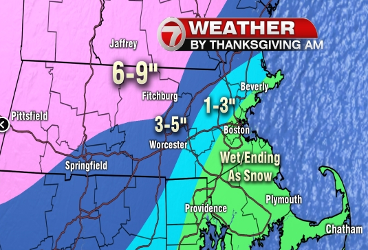
For anyone traveling to the western part of the state, just be prepared for snow. over 6 inches are expected. There will be lots of moisture to work with and likely some banding on the northwest side of the center of the storm, which could be right over parts of our area. Where it is all rain there may be 1-to-2 inches, but where it is all snow, there is potential for a foot or more.


I expect that this forecast will change in 24 hours so I will continue to update this blog one or two times per day.


Sunday, November 23, 2014

3 different computer models

Below are the three computer models showing how much snow we may get on Wednesday night into Thursday morning. I'm sure you can guess which one I like the best.
This first map is the EURO model


 This next computer model is the GFS


This third map is the NAM model. Of course this is my favorite but also the least likely to happen.


Stormy Holiday Week

would you like a white Thanksgiving? Some areas may have some snow for Thanksgiving. First we have to deal with some heavy rain and lots of wind on Monday. then Tuesday should be dry and reasonably warm but everything changes for Wednesday. Wednesday afternoon there is a storm coming up the coast which will bring rain and snow late Wednesday and some may linger into Thursday morning. We have to watch how close the storm comes to the coast to decide where the rain/snow line will be. stay tuned...

Tuesday, November 18, 2014

Up to FIVE feet of snow

Parts of New York near Buffalo are getting up to 5 feet of snow. I can't even imagine what 5 feet of snow looks like. I am so jealous, I would love snow like that around here. Here are some pictures from New York.


Thursday, November 13, 2014

Little Bit of Snow

We are expecting a couple of inches for Friday morning. Not too much, so sad.


Wednesday, November 12, 2014

Here Comes the cold!

Are you ready? the colder temperatures are about to move in. One half of the ingredients, Now I just need precipitation.
cold temps + precip = SNOW!!  
and we all know how much I enjoy the snow


Sunday, November 9, 2014

Colder Weather

Are you ready for winter? The cold temperatures are about to arrive. Cold front is coming in late Friday so temps will be in the 30s starting Saturday.