Tuesday, December 27, 2016

Thursday Nor'easter

There is a storm headed our way but southeast Massachusetts will get mostly rain that ends with a little snow.
The storm will not last very long as it will be starting in the afternoon Thursday and will be over early Friday morning.


There will be some strong winds that come with this storm so power outages are possible.
Even though we will get a lot of rain, the storm will end as all snow. The changeover for my area will begin around midnight.


When the storm is over we should have an inch or two, but if the track of the storm shifts a little to the east then we will get more snow. If anything changes I will post that.


Friday, December 16, 2016

A little bit of snow coming

The cold temperatures will stay in place for another 20 hours so when the next storm arrives it will start out as snow late tonight into tomorrow morning. The snow should change to all rain by noon time but not before we get 3 or 4 inches.

Wednesday, December 14, 2016

COLD is coming

Are you ready for the coldest temps of the year? Friday morning we will have extremely low temps when combined with the wind it will feel like 10 below or even lower. Be sure to dress appropriately. That bitter cold will not stay around long so as the precipitation approaches this weekend it will eventually change to all rain for us.


Monday, December 12, 2016

Next Chance for Snow

Now that this storm is done and sadly we didn't get much snow, I look ahead to the next chance of a storm. Our next chance is this weekend but don't get too excited. This weekend we will warm up so the storm may turn to all rain. I'll keep searching for a chance at a white Christmas.

Sunday, December 11, 2016

Caly Update

I do not have good news for all you snow lovers out there. This storm is so strong it is going to pull in too much of the warm air from the ocean so we will start out as snow but change over to ice then rain.


The morning commute may be a little tricky because that is the time the snow will start to change over to ice then rain.
In the end we only get an inch or two of snow.

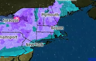
The picture above is from each of the 3 Boston stations
and the picture below is from weather.com


after this storm we have off and on rain for a couple of days. The temperatures will be too warm to support any snow.

Sorry, I really wish this was going to be all snow.

Thursday, December 8, 2016

Here Comes Caly

There is a storm on the west coast right now that is going to travel across the country and hit the Northeast late Sunday. This storm is named Caly. Could we get snow from this storm? There is a good chance of measurable snow from this storm. Right now the local tv stations are saying that the temperatures will be too warm for snow so we get all rain, but there are plenty of sources that disagree. The weather channel feels that the I-95 area has a good chance for snow but it is too early to predict how much


this map from weather channel shows us in the area of 3-5 inches. There is no rain at all on their map.

I also found this post on twitter from Northeast weather. This snow map has us in the 7 inch region


I will continue to follow this and post more as I learn more details about this storm.

Saturday, December 3, 2016

Snow in the forecast

Are you ready? I just listened to the forecast for next week and there are two chances for snow.
The first chance is Monday morning for the commute to school.


Only a tiny amount but I'm sure that is all we need to make the commute a mess.

Then there is a second chance for snow on Thursday. I will keep an eye on this one and report back as we get closer to the day.

Thursday, November 17, 2016

Almost time

We are getting closer to the time when this blog gets very busy. SNOW time! We are in such a drought it makes me wonder.....Will this drought continue and we get little to no snow? or will all the precipitation come this winter in the form of snow? I guess we will have to wait and see.

Thursday, September 29, 2016

Will we have a snowy winter?

Are you a snow lover? If you are a snow lover, then you may be excited about this news. Accuweather.com has released its prediction for this winter. This is the headline from their website.


The farmers almanac agrees with them. Below is a map with the outlook for this winter.


Our local paper The Sun Chronicle wrote an article about the upcoming weather. Below is the headline.


If this holds true then my seniors will be very excited about snow days.


Monday, September 5, 2016

Where is Hermine?

I was really  looking forward to some rain, or should I say my outdoor plants were really looking forward to some rain. According to the weathermen, the storm has slowed down to 3 mph so we wont feel many effects until tonight. The storm has taken a slight turn to the west so there is more of a chance to get some rain. Looks like we will be getting wet on our first day of school.

Saturday, September 3, 2016

Hurricane Hermine

Hermine was once hurricane but is now only a nor'ester. The storm is going to spin around out in the ocean for a while and may strengthen a little. This storm needs to be followed because Massachusetts, at least southern Mass, should get rain and wind from this storm. 
The map above shows the intensity of the storm just south of New England


This map shows the projected path of the storm. Since the storm is coming so close, the first day of school could be interesting. I will continue to watch this and blog an update if needed. Otherwise be ready to get wet Sunday night, Monday, and possibly Tuesday.


Thursday, July 21, 2016

Possible Severe weather Friday July 22nd

During the summer most of the excitement for forecasters is when we have the chance of severe weather and we have that chance tomorrow afternoon. There is a northwest flow headed our way tomorrow. this means there are some upper level winds heading down towards us and they can cause severe weather events with damaging wind. We need to be on the lookout as this may happen Friday afternoon

The map above is from weather.com showing us in the area for possible severe weather.
The chart below is from the National weather service. We are in the yellow category of "slight" for Friday afternoon and evening.


Sunday, May 29, 2016

Tropical Storm Bonnie

Bonnie made landfall early Saturday in the Carolinas. She will be headed this way by Monday. Bonnie will no longer be a tropical storm when she reaches us, only a depression but she should still have lots of rain for us. Do all your outside activities today.


Thursday, May 26, 2016

Hurricane Season

Hurricane season starts next week so this blog will now focus on the tropics. There is a low southeast of Florida which could develop into a tropical or subtropical depression. I will be watching that just in case it brings raining weather to us on Memorial Day.

Tuesday, April 26, 2016

Six Flags Weather Forecast

Most important forecast of the year so far is this Friday. We want to have a decent weather day at Six Flags. I'm sure we will have fun even if it rains, but we will have more fun if the weather is good.
Right now the weather is looking good.


I hope everyone has a great time doing math at Six Flags. Just have to get through two more school days!

Saturday, April 2, 2016

Sunday Snow

Are you ready for a little more winter? We have a couple of inches headed our way tomorrow morning. The snow should start in the early morning and be over by noon time. We will also have to deal with strong winds tomorrow. Wind gusts could be as strong 60 mph tomorrow. The closer to the shore the stronger the winds. may have some power outages too.


After this snow is over we aren't finished with winter. There is more snow on the way for Monday, Mondays snow will be lighter than the snow expected Sunday but the snow may last all day Monday giving us a few inches.


Friday, April 1, 2016

little to no snow

I hope everyone enjoyed the nice warm temperatures the past couple of days because things are about to change. Starting Sunday we will be lucky if the temperature gets up to 40 degrees. There is a chance for a little snow Sunday morning too. An inch at most. The temperatures will remain on the chilly side through Thursday and we may see some flurries Monday and Tuesday but not amounting to anything. By next weekend the temperatures should get back to 60 degrees. I Hope. Where are my nice spring days?

Wednesday, March 30, 2016

More Spring Snow?

Yes, there are two chances for a little snow next week. First there is a small clipper system moving west to east so we could see a dusting to an inch of snow Sunday morning. This is after we have temperatures in the high 60s this week.


The bigger threat for snow is Tuesday morning


This clipper has a little more energy and precipitation associated with it. There is the potential for up to 6 inches but we have to wait until the storm gets closer. I will be sure to keep you posted here on the weather blog

Sunday, March 20, 2016

Sunday night update

I know what is on the mind of all my students - Will we have a snow day tomorrow? It's on the minds of all the teachers too. I have read online that over 40 schools have already canceled for Monday even though the storm hasn't started and some have a delay like Southeastern Voc has a 3 hour delay. I could live with that at Norton.
Most weather stations have kept the same snow totals except these.


Channel 7 moved the 6-8 inches lower and channel 5 had 8+ inches but that is gone now.

In addition I found a snow total map from channel 10 in Providence


and the National Weather Service updated their map at 4:30 this afternoon putting Norton in the 7-8 inch range


The timing for this storm is awful for people that have to drive to work tomorrow morning


The snow will be coming down pretty heavy at 6:00 am.

As of 8:30 tonight there are two schools close to us that closed for tomorrow. They are Attleboro and Bishop Feehan. Now we wait and see if we get the call.


Snow Storm Regis

Here is your morning update...Things have stayed pretty much the same as last night. A couple of meteorologists have increased the amounts


The snow will not start until after dark and because the temperatures have been warm lately the snow will not stick to the road ways right away so driving tonight shouldn't be bad but it may be a different story by the time of the Monday morning commute.
I will blog again tonight with any late updates. Enjoy your Sunday.

Saturday, March 19, 2016

Latest on Storm Regis

So our expected snow storm has a name, Regis. Regis should be arriving after dark Sunday night and continuing through Monday morning. The timing of the heaviest snow is for the morning commute.
You may have heard earlier today that the storm was going out to sea and we would only have an inch or two. Well I didn't blog about that because I didn't believe it and now the weather people have all said the storm went back to the west so the totals are higher. Below are all the latest snow total maps.


I will blog again later tomorrow if there are any changes.


Friday, March 18, 2016

7 o'clock update

I know I said I wouldn't blog again today but the six o'clock weather reports had snow total maps so I wanted to post them.


I'll be back to blog tomorrow night.


Here is your 2:00 update. The snow is still coming our way. The track has shifted a little to the East which just means the heavy snow area has moved a little to the south. This is what was first expected


now with the small shift to the east the heaviest snow is moving southward.


Every station continues to just say the potential is there for 6+ inches. I guess we will have to wait until the storm gets closer. I will not blog again today, but I will tomorrow afternoon.

The National weather service did post a map with the expected totals by Monday morning at 7 am. Keep in mind that the snow will continue to fall until late morning so these totals may increase. this map has Norton in the region of 7 inches.


If the storm track doesn't change we should get a sizable amount of the white stuff. Please be careful if you have to shovel because the snow will be the wet heavy stuff.

Snow Day Monday?????

If this storm track does not change then we may have Monday off. Right now everything is pointing to a foot of snow Sunday night into Monday. If the storm track changes then the snow amount will change. We just have to wait until the storm is closer. The storm is still over 48 hours away. Yesterday I posted the totals that Weather channel was predicting. Today I have a snow total map from Accuweather.com and they are pretty close to the same as weather channel.


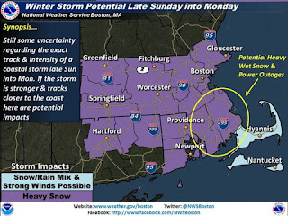
This snow is supposed to be wet and heavy so there may be some power outages. Make sure you are prepared for that. I will make sure I have flashlights, candles and that all my technology is fully charged or maybe I will go old school and read a book by candle light.

The National weather service put out this map for areas at high risk for power outages.


I will be back again this afternoon with any and all storm updates.