Wednesday, November 26, 2014

Lower Snow Amounts

Surprise surprise, the snow total maps have changed. Most meteorologists are now going with lower snow totals. Below are a few of the new maps.


Tuesday, November 25, 2014

Storm has a name - Cato

Here are a few additional snow total maps


The map below is from the weather channel. This map had some smaller amounts last night to maybe this is a trend...upping the totals. Norton is on the line for 5-8 inches, highest amount I have seen for this storm.


Monday, November 24, 2014

The first snow maps are in

The National Weather service has extended the Winter Storm warning a little further to the east which means the rain we are forecasted to get should turn over to snow. Now the question is when will that turn over occur? The sooner the turn over the more snow we get. In the end we aren't supposed to get much. I wonder how many times this forecast will change between now and when the snow starts. Four television stations have posted snow total maps and I am happy to share them with you. If any of these amounts change I will post again. My favorite is the first one.


Snow update

The chance of this storm going out to sea is pretty close to zero percent now. We will be getting moisture, and lots of it. The questions remains, Who gets snow and who gets rain and how much? As of this afternoon all reports that I have read state we will start out as rain late morning/early afternoon and we should change over to snow for the evening commute.


How much snow we get depends on when the change-over starts. The storm is expected to wrap up by Wednesday late evening. If the rain doesn't change to snow until 6 or 7 pm then we should only get an inch or two


For anyone traveling to the western part of the state, just be prepared for snow. over 6 inches are expected. There will be lots of moisture to work with and likely some banding on the northwest side of the center of the storm, which could be right over parts of our area. Where it is all rain there may be 1-to-2 inches, but where it is all snow, there is potential for a foot or more.


I expect that this forecast will change in 24 hours so I will continue to update this blog one or two times per day.


Sunday, November 23, 2014

3 different computer models

Below are the three computer models showing how much snow we may get on Wednesday night into Thursday morning. I'm sure you can guess which one I like the best.
This first map is the EURO model


 This next computer model is the GFS


This third map is the NAM model. Of course this is my favorite but also the least likely to happen.


Stormy Holiday Week

would you like a white Thanksgiving? Some areas may have some snow for Thanksgiving. First we have to deal with some heavy rain and lots of wind on Monday. then Tuesday should be dry and reasonably warm but everything changes for Wednesday. Wednesday afternoon there is a storm coming up the coast which will bring rain and snow late Wednesday and some may linger into Thursday morning. We have to watch how close the storm comes to the coast to decide where the rain/snow line will be. stay tuned...

Tuesday, November 18, 2014

Up to FIVE feet of snow

Parts of New York near Buffalo are getting up to 5 feet of snow. I can't even imagine what 5 feet of snow looks like. I am so jealous, I would love snow like that around here. Here are some pictures from New York.


Thursday, November 13, 2014

Little Bit of Snow

We are expecting a couple of inches for Friday morning. Not too much, so sad.


Wednesday, November 12, 2014

Here Comes the cold!

Are you ready? the colder temperatures are about to move in. One half of the ingredients, Now I just need precipitation.
cold temps + precip = SNOW!!  
and we all know how much I enjoy the snow


Sunday, November 9, 2014

Colder Weather

Are you ready for winter? The cold temperatures are about to arrive. Cold front is coming in late Friday so temps will be in the 30s starting Saturday.


Thursday, October 9, 2014

Fall Foliage

Do you like fall season? maybe you like all the colors. If you enjoy viewing the colorful scene here is a map showing where you can get the best color.


Friday, September 19, 2014

10 day forecast

Here is the 10-day forecast from NECN. Enjoy this nice dry weather to end September.
The starting date is Friday September 19th and the last date is Sunday September 28th.


Wednesday, September 17, 2014

Dry Summer = Wet Winter?

According to the graphic below we have not had much precipitation lately and we are due. I was thinking....If the wet weather decides to come visit us during the colder months we could be in for quite a bit of snow.


Some of the weather experts agree with me because of the El Nino. Below is a map from accuweather showing that they predict we will have a snowy winter. If that comes true I will be so excited. There will be lots to blog about because we all know how much fun I have with weather in the winter.


Thursday, September 11, 2014

Up coming Winter

Here are a couple of maps I found that forecast the winter coming in a couple of months
according to these maps we may be in for s snowy winter.
sounds good to me.


Thursday, September 4, 2014

Back to School weather

when returning to school the last thing I want is hot and humid weather. Unfortunately thats exactly what I got this week. I can't wait until the temps go back down to 70 degrees or below. Thats perfect weather for school.

Saturday, July 5, 2014

Here comes the heat and humidity

Well we survived Hurrican Arthur. This weekend has given us some nice dry weather. My favorite part of the weather has been the lack of humidity. I love the hot temps but hate the humidity. That means I will not like this week as the humidity makes a return. I love how channel 7 measures humiduty using this graphic of how your hair will look.

Wednesday, July 2, 2014

Not a Hurricane yet

Arthur is still a tropical storm but is expected to strengthen  to hurricane status tomorrow. A storm reaches category 1 status when the winds near the center reach 74 mph. We have some weather to contend with before the storm gets any where near us. Tomorrow, Thursday Juy 3rd, we have a chance of some strong storms.


Then we get ready for some heavy down pours on Friday. Notice on the maps below that the national hurrican center has part of Massachusetts in what is called "The cone of uncertainty" This is the area where the path of the storm could go. If the storm comes closer to us then of course our weather will be much worse.


The many computer models are shown below and the majority of these computer models keep the storm 50-100 miles east of Massachusetts.


Hopeyou don't have outdoor plans for Friday like I do. Cookout and pool party at my house. Maybe not!

Tuesday, July 1, 2014

Tropical Storm Arthur

In the winter months I love to follow the predicted snow storms and in this warm weather, I follow another type of storm - tropical storms
The first named tropical storm of the season is here. Say hello to Arthur
 
 Arthur is currently located off the Florida coast and is traveling Northwest  at 5 mph.


Now we wait and see how strong the storm gets and how close this guy comes to Massachusetts.

 
I will be sure to post daily updates on this storm

Wednesday, June 4, 2014

Important Weather Week

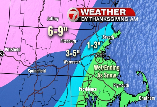
The weather is playing a part in my life this week and in the life of all my seniors both at home and at school. Thursday the Norton High seniors have their annual trip to six flags and I don't like all the rain in the forecast. Then we have the all important Graduation night on Friday and last year we had downpours. I don't want a repeat of that this year. Sunday my son has his graduation party and since the party is outdoors by the pool we would like some sunny weather.

This is the hourly forecast for Agawam, MA (according to weather.com) for the times that the seniors will be there. Bring your rain coat. Don't worry, you will still have a great day. Fun in the rain,


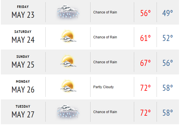
On a happier note the weather for graduation night is looking good.


Then there is the big party at my house on Sunday. Looks like Bryan is going to have a great weather for his graduation party. Good thing, I don't know how I would have fit all those people in my house.

Sunday, June 1, 2014

Hello Hurricane Season

June 1st is the start of the hurricane season. Below is a graphic showing the number of named storms per month (on average). A storm is first recognized when it is a tropical wave, then it becomes a tropical depression. The next step is a tropical storm when a name is assigned, if the storm continues to strengthen a hurricane may be formed.


 The next graphic shows what the National Oceanic and Atmospheric Administration predicts for storms this year.

Here are the names for this year's storms. See your name any where?

Thursday, May 22, 2014

Long Weekend

Are you ready for a 3-day weekend? I sure am. Too bad the weather isn't going to be better. We have a chance of rain for the next 3 days but on the bright side, the temperatures will be going up.
According to the radar we have rain about to arrive.


I don't mind if it rains tonight or tomorrow morning but then I would like it to stop and brighten up.