Sunday, January 31, 2021

Snow Anyone?

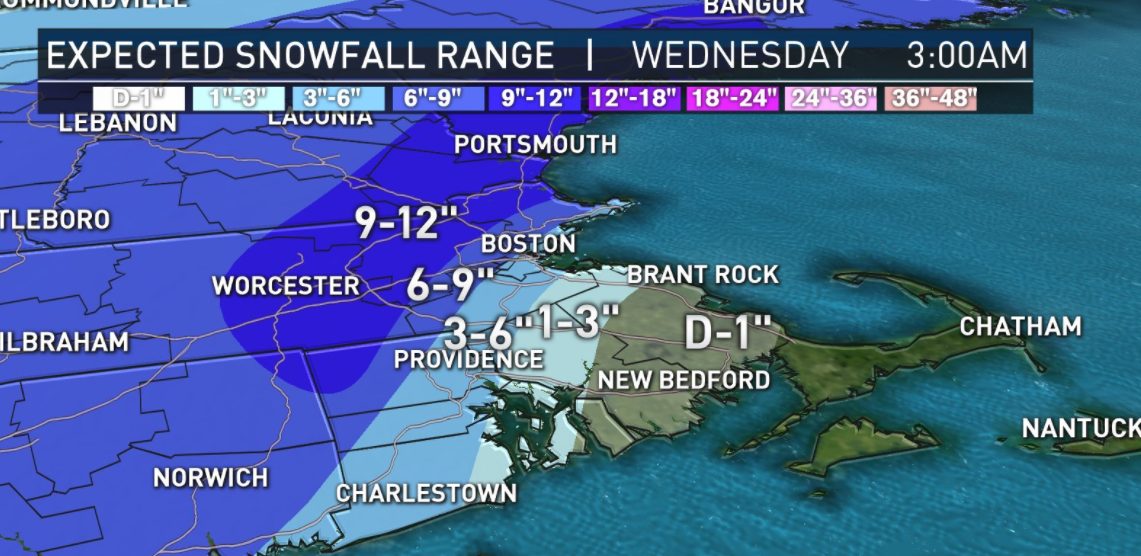
 As expected the snow total maps have changed yet again. Everyone seems to be increasing the amounts of snow since the storm is now tracking a little further south and the cold air is going to stay in place longer so the snow shouldn't change to rain until midnight or maybe even a little later.

I have found all the snow total maps posted by the local TV stations and I have a few from independent weather people on twitter. 


If anything changes, then I will post again tomorrow morning.
Enjoy the snow


The latest on the Monday-Tuesday snowstorm

 Here is the latest -

The snow amounts haven't changed much over night but the timing of the storm has changed. The snow is going to arrive sooner than expected and this may turn into an all day Monday event and very little Tuesday morning. That changes the thinking for a snow day on Tuesday. 

Everything could still change depending on the rain/snow line. If that moves a little further south then we get a lot more snow. 

Here are the snow total maps that were posted this morning


I will be back late this afternoon with another update. Until then Think Snow


Saturday, January 30, 2021

Snow amounts trending down

 I do not have good news for all my snow lovers out there. The latest track of this storm is bringing in warmer temperatures so the Norton area will have a mix of rain and snow keeping amounts down. However, what does fall as snow will be wet and quite heavy so be careful when shoveling.

These are the latest maps from all the news stations and independent agencies


I'm sure this will change over night so I will be back tomorrow early afternoon to post another update with the latest snow total maps.

Even though the amounts of snow are decreasing I still think it will be messy for Tuesday morning's commute so there is still a good chance of a snow day,

Tomorrow I will get a better idea of the timetable for this snow. There are two basketball games scheduled for Monday afternoon at Norton High and I really don't want them to be postponed.
See you Sunday.


Mon - Tues snow Do we see a foot of snow?

 Some snow total maps have changed over night. Some show a little less snow for Norton but others still say a foot.

Here are all the maps I could find as of noon time. I may post again tonight if the maps change for the 6pm news.


Friday, January 29, 2021

Winter Storm Orlena

 We have the potential for a significant snow storm to start the month of February. Winter Storm Orlena, named by the weather channel, is due to arrive in our area Monday afternoon and last through the early morning hours of Wednesday.


The precip will start out as light snow Monday early afternoon and then get heavier and steadier Monday night. There is a low pressure off the coast and where and when that develops will decide the track of this Nor'easter. 

There are a few snow total maps out as of 6pm tonight and here they are


I'll be back tomorrow to post updated snow total maps. See you then


Thursday, January 28, 2021

weekend forecast leading into our next snow storm

 Are you ready for some cold weather? I mean really cold for us! This winter has been quite mild. I have been wearing just a sweatshirt to school everyday but I do believe I will need to wear my winter coat tomorrow. Friday's morning temperature will be single digits and with the wind chill it will feel like it's below zero! Dress warm

The temperatures will go up a little over the weekend. Saturday temps should be in the 20's and then the 30's on Sunday. Then we focus on the precip coming our way....


The potential is there for a nor'easter Monday and Tuesday. I will have to keep an eye on where the rain snow line is located for this storm. You know the story - could be a foot of snow or rain/snow mixed depending on the storm track.

I'll keep you posted.

Monday, January 25, 2021

Light snow coming our way

 Hello snow lovers. Sorry I don't have any news of big snow storms coming our way. There is a small storm bringing one to three inches of snow late Tuesday night into Wednesday. 


Then brace yourself for some cold temperatures headed our way  for the rest of the week


Our next chance for snow will be Sunday night (Jan 31st) into Monday and may actually linger until Tuesday morning.
I'll be back at the end of the week to blog about that storm.


Sunday, January 3, 2021

start of 2021 with a little bit of precip

 You may have noticed some light snow falling at this time. I am actually surprised to see snow this early as I wasn't expecting it until 7 or 8 tonight.  Don't get too excited. This isn't going to amount to much. This light snow won't last very long. We will have a couple of dry hours and then there will be a little more snow maybe mixed with freezing rain before changing over to all rain. Nothing too exciting to blog about. 

I don't see any big snow makers in our immediate future but I will be keeping a lookout.

Happy New Year.