Monday, January 29, 2018

chances for snow

There are a few chances for some snow in the next two weeks. None of these chances looks to be very big but I will keep an eye on them all. The first chance is tonight into tomorrow morning. The further south you live the more snow you will get. Here are a couple of maps.


We have another chance for a little snow Friday and then again next week on Wednesday. I'll continue to post updates.

Tuesday, January 16, 2018

Wednesday's snow

I have had several students stop by my office today and ask if I think we will have a snow day tomorrow. My response to them is - If you have a midyear exam tomorrow I would be sure to study for that tonight. We are not going to get much snow tomorrow and the latest reports are stating that the rain/snow line is shifting further north. NBC Boston has us in the 3" range as seen below and then I have the write up from the weather channel


But I am not completely sold on this storm being nothing when I read weather advisories like this one


This advisory states that travel conditions will be difficult in Foxboro tomorrow morning and that is only a couple of miles from here. This weather statement also states 5-7 inches in Foxboro. I find it hard to believe that a town so close can get 2-4 inches more snow. I guess weather can be funny like that. 

All I can say is that this snow has me confused. 
This will be my last update today because I will be scoring the basketball tonight.  But of course if things change drastically I will update around 9pm when I get home from basketball.


Snow coming tomorrow (wednesday January 17th)

This snow storm has me very confused. Some forecasters say near 6 inches while others say only 2 inches. I personally am hoping for just the 2 inches. I don't want a snow day in the middle of Midterm exams. Here are the latest maps from this morning.


Monday, January 15, 2018

A little snow Wednesday

We have a little bit of snow headed our way this Wednesday. Right now it doesn't look to be too much but there are a few inches coming our way. The total amount could be any where from 2 - 6 inches. hopefully the weather people will fine tune this tomorrow and I will post updated snow maps. This is what I have found so far.


Monday, January 8, 2018

Here comes the warm up

I hope everyone is all shoveled out now. We are expected a little snow early tonight but that shouldn't be more than an inch. After this snow the temperatures will be on their way up each day and we will reach low 50's Thursday and Friday so there will be a lot of melting going on.
Be sure to get out and enjoy the sunshine when you can and I will let you know when we have the return of winter.

Friday, January 5, 2018

Dangerous temperatures this weekend

I hope everyone enjoyed the blizzard of 2018. I enjoyed the two snow days I got from the storm. I measured in three different spots in my yard and took an average so I got 17.67 inches of snow


Now we have to make sure to have some indoor plans for this weekend. Temperatures will be very low. The low temps of the days will be below zero and the windchill could reach 20 below. If you have to go out please be safe. Don't leave any skin exposed.


Wednesday, January 3, 2018

Snow Storm Grayson

Let me start this blog by saying I am not a meteorologist nor do I pretend to be. I am just a math teacher that is fascinated with weather and a teacher who loves her snow days. I watch multiple weather forecasts and read everything I can about weather. These blog posts are based on everything I have read and contain all the snow maps from as many different sources as I can find. Now on to the latest about tomorrows expected snow...

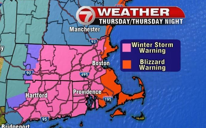
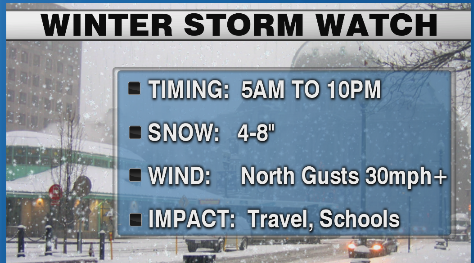
The snow storm due to arrive early tomorrow morning has been named Grayson.  The National Weather Service has issued a Winter Storm warning for our area.

  • Winter Storm Warning indicates that heavy snow of at least 6 inches in 12 hours, or at least 8 inches in 24 hours, is expected. It can also be issued if sleet accumulation will be at least half an inch. 

The NWS has also issued a blizzard warning for the area just to our east and south.

Blizzard Warning indicates that blizzard conditions (low visibility of less than 1/4 mile due to falling and/or blowing snow, and winds at least 35 mph) are expected for at least 3 hours.


This storm is going to be a powerful one. The very cold temperatures and high winds that follow this storm will make it very dangerous. From everything I have read about Grayson and all the weather forecasts I have watched I get the feeling that many of us will lose power and that means losing heat. That makes me very concerned about the pipes freezing and bursting in my house. Guess I will be running the water for the next 24 hours straight.

The snow should start before the morning commute. I have read that there will be times that the snow is falling at 2" per hour. That will make driving a little difficult. The worst of the storm should be over by early evening Thursday. 

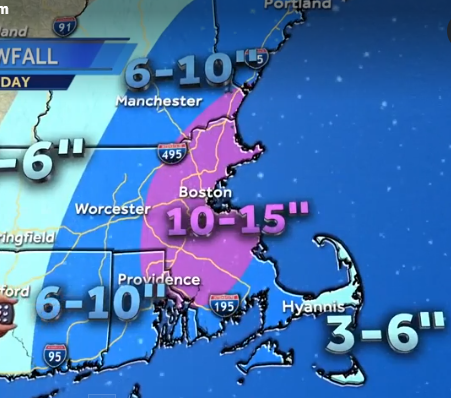
Grayson has taken a little bit of a left turn. With the track going a little more towards the west that means some rain for the cape. Rain may keep the snow totals a little lower there. That also means that the snow falling in southern mass (near the rain line) will probably be the heavy wet snow. Most stations have kept the same amounts of snow for this storm. Here are a few


All the maps put us in the area with at least a foot of snow.
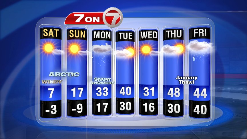
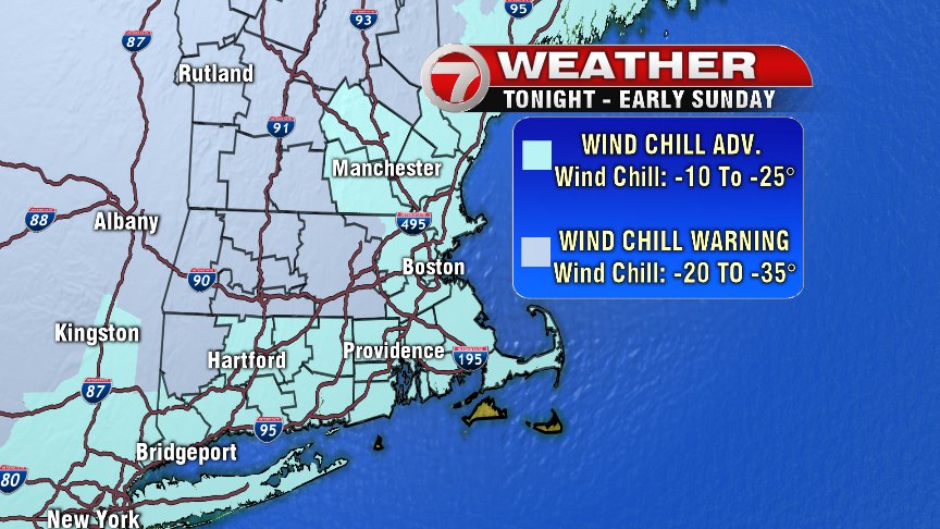
After this storm leaves us we have very cold temperatures to deal with. We will have wind chill temperatures as low as 15 below Friday night into Saturday. Stay warm everyone


higher snow amounts

Since my last post the snow totals have gone up. Most television stations are reporting amounts of a foot or a little more. Below I have posted the maps that have changed since my last post. I am more concerned about wind and power outages than I am snow amounts. Many people are going to lose power which means they will not have any heat. Please be prepared for that. Norton is very close to the blizzard warning so we should get some pretty strong winds.


Here are some new snow total maps. I will find more and update later this afternoon.


Tuesday, January 2, 2018

More About Thursday Snowfall

This will be my last post for today. A few meteorologists have changed their snowfall totals to higher amounts.

Earlier today the totals from channel 7 were 4-7+ and look now. 8-12 inches has me excited. I just hope everyone is prepared for this storm. A foot is a lot of snow and There will be high winds which means power outages which is dangerous with such low temperatures. One other reminder is to fill your gas tanks because if there is power outages gas stations will be closed.

This map below from meteorologist Dave Epstein caught my interest with his message in yellow writing of 12+ inches are possible in some areas.


I will update snow total maps tomorrow afternoon. Maybe the amounts will be even higher. 

Snow Totals

more snow total maps are coming in now that the storm is less than 48 hours away.  The storm is expected to start in the early morning hours of Thursday. Below are the weather headlines from two local stations. The first is from WPRI in Rhode Island. I love the fact that they put in writing schools will be impacted. I guess they expect snow days


This next graphic is from WHDH in Boston. The dangerous cold on Friday scares me too.


Here are the latest projected snow totals. Please keep in mind that these amounts may change depending on the exact track of this storm. That means I will probably be posting a totally different batch of maps tomorrow. 


Notice the temperatures for the day after the storm. Much too cold!! and with such heavy winds we may lose power. Friday is not the day you want to be without heat. Please prepare in advance.


The first snow total maps

The first snow total maps are in. Keep in mind that these maps will most likely change as the storm starts to track North. This storm is coming up from Florida where they may see some ice from the storm.


Weather channel has our area getting Five inches and fox 25 says we may get 5-7 inches.

As soon as new maps come out you know you can find them here.

Monday, January 1, 2018

Thursday Snow

I am still waiting to hear the track for our upcoming storm. As of right now the storm will travel a path that keeps it out at sea. If the storm track doesn't change we may see 4-6 inches of snow in this area.  I haven't been able to find any snow total maps just these two maps with a little bit of information.


The storm should start early on Thursday and continue into the night. When I have more information I will blog about it. I am hoping to update this blog each day.