Saturday, January 31, 2015

Winter Storm Linus bringing us more snow

Here comes more snow and possibly another snow day. Weather forecasters are predicting a foot of snow, maybe a little more. all areas should be getting snow by 2:00 am Monday and the snow will continue right through to the early evening. Here are three snowfall maps that I found. all three say the same thing so get the shovels ready, AGAIN.


Friday, January 30, 2015

A little more snow than previously reported

Since I last blogged the weather channel has increased their snow amounts. Now they are reporting
 8-12 inches. I still need to find a time for this storm to start. I am sure my students would love another snow day. Some forecasters are reporting early morning start and some say a little later. I will keep checking on that.


Ready for more snow?

I hope everyone is enjoying the light snow falling today. This shouldn't amount to much. Maybe two inches. The storm that may give us more is coming early Monday morning. The storm seems to be tracking south which means cold air for us which means all snow. Most forecasters are saying 6-8 inches. I will update the blog when I know more. After Monday's snow we have to keep an eye out for Wednesday night into Thursday.


Thursday, January 29, 2015

two more chances for snow


The seven day forecast shows snow on both Friday and next Monday. Friday's snow will come in two parts. a mix of snow and rain for the morning commute and then very very light flurries throughout the day. At night the back side of this storm will throw some more snow our way but only 2-3 inches.

Monday's snow has the chance to be more significant but could also pass too far out to sea. Stay tuned. As the storm gets closer meteorologists will have a better idea of the storm track.

Tuesday, January 27, 2015

Blizzard of 2015

The snow continues to pile up here at my house and I just got word that school is closed again tomorrow. (Wednesday January 28th). I sure do love my snow days. I think my seniors are very happy right now since they don't have to make up snow days.

I ventured outside two hours ago and got some pretty high snow measurements (2 feet) and the snow is still coming down at a steady rate. Will we get 3 feet? This was my measurement from 12:30 pm today.


This was the furniture on my back patio at 10pm last night and the picture below is the same furniture at 8 am this morning. Pretty soon we won't be able to see any of the it.


This is not the end of the snow for us. There are two more storms I am watching. One storm comes in Thursday night into Friday and then a potentially bigger one for next Monday. Stay tiuned for more details and enjoy your snow day.


Monday, January 26, 2015

State of Emergency

Gov. Baker has declared a state of emergency as two feet of snow are headed our way. He also issued a mandatory travel ban effective at midnight. Only essential vehicles are allowed on the road.
Logan airport will be closed Tuesday and the last flights leaving or arriving will be at 7 tonight. The MBTA system is not running Tuesday.

Gov. Baker says power outages are a possibility in southern Mass. and those outages may last for days. Be prepared.


The latest on Juno

Not too much has changed since the last time I blogged but I just love writing about big snow storms. The radar is showing that the snow is already falling in southern Massachusetts. Won't be long now.

by 7 tonight there should be 2-3 inches on the ground
at midnight we should have at least 6 inches
and a foot by 7 tomorrow morning.

The snow will continue all day Tuesday and into the early morning hours of Wednesday. Any snow that falls Wednesday morning will be very light.

Here are the latest maps with snow totals


Sunday, January 25, 2015

Juno update

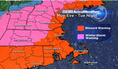
A couple of things have changed since my last post. First the blizzard watch has become a blizzard warning. That means there will be high winds blowing snow with little visibility for sustained periods of time. 


Second The timing of the storm has changed a little. We may start to see flakes as early as 2pm. This will be light snow with the initial band of steady snow coming in around 5-6 pm. By midnight we should have around 5 inches of snow on the ground. 

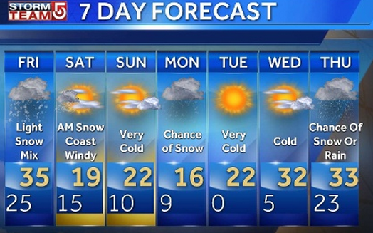
The following quote comes from the wbz tv weather blog. They are predicting a couple of snow days


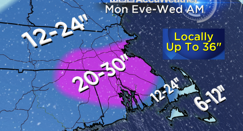
The snowfall amount remain the same of 2- 3 feet for this area.

as always I will post if anything changes. Make sure you have candles and batteries in case we lose power and make sure your phone is fully charged.

Storm JUNO

Be prepared for a long duration storm Monday to Wednesday. This storm named, Juno, is due to arrive early Monday evening. We could have an inch on the ground by 7:30 pm


There may be power outages because the winds are expected to be around 50 mph


NECN has put my town in the snow range of 24 - 36 inches. Thats 2-3 FEET!! wow


Here are a few of the other snow total maps that have been posted. If there are any changes I will be sure to let you know. If you hear of any changes feel free to comment on this blogs. Safe travels. Probably best to stay inside on Tuesday.


Blizzard?

The official definition of a blizzard is:Sustained winds or frequent gusts of 35 miles per hour or greater and visibilities less than 1/4 mile for at least three consecutive hours.

If the snow falls heavy enough to produce the low visibility we may actually have a blizzard here on Tuesday. 

This next storm should arrive Monday night (7 - 8 pm) and continue to early Wednesday morning. Most meteorologist agree that we should have over a foot of snow.  
This one has me all excited. Mother Nature better not disappoint me. I will continue to follow all the weather reports and update the blog tomorrow.

Saturday, January 24, 2015

Messy Saturday

good morning everyone, If it is still snowing at your house get ready for the rain. Every where south of Worcester is going to see rain. Being a snow lover, rain is my worst enemy. So much snow will be washed away. There will be a short period of light snow again at the tail end of this storm around 4 this afternoon but that won't amount to more than an inch or two.
What has fallen here looks very pretty and there is another chance for snow late Monday night into Tuesday. I'll keep you posted.
here are a couple of updated maps for today


Friday, January 23, 2015

More snow total maps

Hello everyone, Not much has changed since my posting this morning. Every meteorologist does keep saying if the track of this storm changes then things will be a lot different. I will be up late tonight watching every weather forecast and then I will update around 11:30.

Here are a few more maps with snow totals
The two Rhode Island stations seem to agree on a large area of 4 inches.


The map below this is from NECN where they have totals slightly lower


The last map I have is from weather.com. you might have to enlarge the map to see where your area falls. Wish I was in the purple 8-12

Saturday Snow

Are you ready for a little white stuff? We have a storm headed this way but the further south you live the more rain instead of snow you will get. The storm should start as snow around 8am and then gradually change to rain and then back to snow again for the end of the storm. Should be out of here by 8pm. The most intense part of the storm should be between 12noon and 3pm.
Below are the three snow total maps that I could find. I will update this blog some time this afternoon.


Wednesday, January 21, 2015

3 chances for snow

Are you feeling as depressed as I am not having any snow? I need some snow and by some I mean a lot. I may get my wish soon. There are three chances in the next week
#1 - tonight we will be getting some precipitation. unfortunately this may amount to only an inch or two.


chance #2 comes along this weekend. Late Saturday afternoon into the night. The chance is there for 6 inches but as usual we have to watch the track this storm takes


Chance #3 comes Monday night into Tuesday. The potential is there for this to be a moderate storm. Time will tell us more and you know I will be following each of these storms and updating when I know more.

Saturday, January 3, 2015

weekend storm

There is a storm headed our way, unfortunately for us snow lovers the temperatures will be too warm so we will get mostly rain in our area. around 7 pm we will start to get some snow, but the snow will not accumulate much


By midnight our area should see all the snow change over to rain.