I just went on to facebook and saw this post. I guess I will have to watch some weather and report back here tomorrow.

I just went on to facebook and saw this post. I guess I will have to watch some weather and report back here tomorrow.
Ready to get wet? Looks like the temperatures will be quite warm for Thursday and Friday this week so the precip we get on Christmas Eve and Christmas day will be rain. LOTS of rain and some wind to go along with that.
After that the temperatures will stay in the upper 30s and low 40s so any precip for the rest of this calendar year will probably be rain.
I'll be back with an update when I hear about a possibility of snow (more than an inch)
The next chance for snow is Christmas night and the next morning. Right now looks like 1-3 inches Christmas night and an additional inch or two the next morning.
I'll keep you posted.
Are you ready for over a foot of snow? The snow has entered Connecticut and should be here around 8:00 tonight. This storm will come with some strong winds around 35 mph so make sure you are prepared for a possible power outage. The heavy snow, with rates of 1-2 inches per hour, will continue through the night into early Thursday morning. Then there will be light snow for the rest of the day Thursday.


I did a quick check of some weather stations this morning and there haven't been any changes in the snow maps. Everyone is still predicting a foot of snow in our area and a little less on the cape. The beginning of the storm may have some wet heavy snow but eventually that will change over to the light fluffy stuff. Be sure to get the snow cleaned up Thursday afternoon/evening because cold temperatures will be here for a few days. The low temp over night Thursday into Friday is single digits.
I'll be back this afternoon to post an update on the snow maps. Enjoy the calm before the storm.
I did find this one new map from eweather on Twitter

Hello snow lovers, The storm has changed a little bit. The track moved a little north so the high amounts of snow have now moved into towns further North and lower amounts will now accumulate on the cape.
The snow will move into our area between 7 pm and 8 pm Wednesday and will continue throughout the day Thursday.
Here are all the latest maps I could find.


Here you go...


Hello to all my fellow snow lovers out there. Are you ready for a snow day? Looks like we may get one on Thursday. The weather channel has named this storm "Gail".
Gail is due to arrive Wednesday night any time after 7:00. This snow should be light and fluffy so it will be easy to shovel, but there will be a lot of the white stuff.
Right now the track of the storm is just south of Massachusetts bringing most of the snow to southern Massachusetts. If the storm track where to go further south, then we would have less snow.
As of 3pm this afternoon there are a few stations putting out maps so here they are.


Hello everyone, I am doing some of my favorite things tonight. I am watching the Disney Holiday sing-a-long as I research the snow storm heading our way.
First - we have a little storm bringing us some snow tomorrow (Monday) and then ....


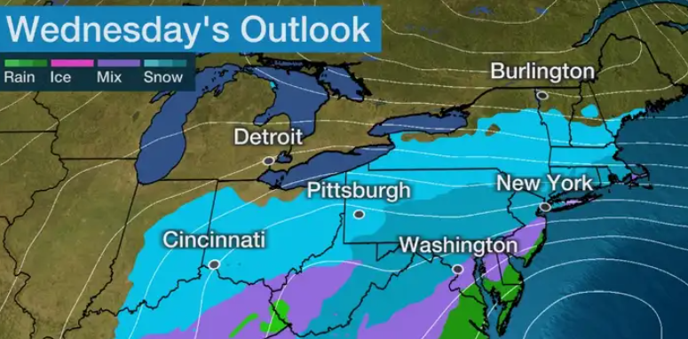
I checked several weather websites today and the Northeast is still expecting a snow storm Wednesday into Thursday. The Nor'easter is expected to start midmorning on Wednesday and since a high pressure from Canada should have cold air in place we will get snow.


This is the headline on the Accuweather website


Hello to all my snow lover friends. The winter storm named Eartha, has taken a track a little further south and the rain has switched over to snow a little earlier than expected so the snow totals have gone up a few inches. Here are all the latest maps I have found.


