Saturday, February 21, 2015

Tonight into Sunday

Is everyone prepared for more snow? I believe this weather is quite a jolt for my son and all the other cadets from Mass Maritime as they arrived home today to temperatures of 15 degrees after being down south in St Thomas, Puerto Rico and Ft Lauderdale. My son has a nice tan.
back to the snow...the colder temps may be around a little longer than expected so the change over to rain will take place later than expected which means some higher snow amounts than originally predicted. Here are a couple of snow total maps I found.


Friday, February 20, 2015

Another Day another snow storm

Same old story here. There is more snow on the way. We have snow in the forecast for Sunday and Wednesday. Sunday's snow will probably change to rain but looks like Wednesday is all snow.
Saturday night the snow begins, after a few hours we will have a wintry mix and then rain. We will only have a couple of inches.

Then we get more precip on Wednesday and Wednesday evening. This will accumulate a little more than Sunday. According to the early predictions on weather.com we should have 4-8 inches.


Monday, February 16, 2015

Changes to Tuesday's storm

Time to get ready for our next round of snow. The good news is that we will not have to shovel as much this time around. The snow is coming in earlier than expected. We should see the first flakes falling as early as 6:00 am.

Most of the snow total maps are the same around 3 or 4 inches for this storm.


This snowfall may move us up to #2 snowiest winters. Will we be #1 before this winter is over? I believe the answer to that question is yes. More snow is on the way for Sunday. I'm hoping that does not happen because my son has been out on the Mass Maritime ship and the ship is supposed to return Sunday. Bad weather may change those plans.

Sunday, February 15, 2015

That's not the end of the snow

Winter storm, Neptune, is winding up today and moving out. Hopefully the wind doesn't cause any power outages as we go through the afternoon.

Once this storm ends we only get one day off and then we get more snow. Yes I said more. Winter storm, Octavia, will be bringing snow our way late Tuesday afternoon and then we have a chance for even more on Saturday. I don't think we will have any trouble getting to #1 winter for the most snow. Right now we are at 89 inches and with two more chances of snow this week we make hit #1 before February school vacation is over.


Below is a snow map from weather channel showing what we have to look forward to on Tuesday afternoon. The early amount talked about is 6 inches but we have to wait and see as the storm gets closer. Right now the storm is bringing snow to Nashville. 


We have had so much snow that my students are having fun building snow forts.


Thursday, February 12, 2015

Weekend Blizzard???

We have an inch or two of snow coming tonight. That's nothing compared to what we have been getting and what we are getting again this weekend. The heaviest snow falling late Saturday night into Sunday.

One thing I have noticed about this weekend storm is that all the TV stations are agreeing on the amount of snow. A foot or more. I just want to know the answer to one question.
Where are we going to put all this snow?


After this storm, possibly blizzard, we turn our attention to Tuesday night. I am just glad that I am on school vacation so I don't have to worry about missing another day of school.

Wednesday, February 11, 2015

More More More

This weather pattern is relentless. The snow doesn't want to stop. We will have light snow flurries today, tomorrow, and Friday. There is a storm Thursday night but that will be developing out over sea so we will only get an inch or two. The cape may get 4 inches.


as you can see from the graphic above we have a chance at a storm Saturday night and then another one next Tuesday. As those storms get closer I will be able to give you more details.
If Thursday night's storm comes any closer to us which means lots of snow I will let you know.
Stay tuned

Tuesday, February 10, 2015

Thursday snow

Looks like the worst of this next storm will be off shore but we still get snow and wind. There are two possible tracks and right now the storm appears to be taking the southern track. If that storm moves a little close to land then this storm gets much worse.


I guess I will have to repeat what all the weather people say, "We'll know more as the storm gets closer" In other words I can tell you more Wednesday night. Right now it appears as though the snow will start falling early evening on Thursday and continue all night to Friday morning.

 
Most stations are reporting around 6 inches but remember if the storm comes closer we will double that amount.

Monday, February 9, 2015

Have you had enough?

If you answer yes then you do not want to read this blog post. More snow is on the way and possibly a lot more snow. We have two more storms headed this way.  The 7 day forecast shows nothing but snow flakes


This is the headline from the channel 5 web site.
 

Storm #1 comes in on Thursday and heavy snow Thursday night. This storm is following the same typical path that could bring the storm further out to sea which would mean less snow for us. Right now the storm models show the storm is close enough to produce heavy snow. you will have to stay tuned for more updates tomorrow.


Storm #2 sets itself up off the east coast Saturday and we get more snow for Valentine's Day weekend. When does it end????????????

Sunday, February 8, 2015

Snow Storm Marcus

Marcus is going to bring the heaviest and steadiest snow later today (evening) all through the night and all day tomorrow. The snow should end around 1 or 2 am Tuesday.
The graphic below is am estimate of how much snow will be on the ground at each of the times. so by 7pm Monday night we will have between 10 and 15 total inches and a little more may accumulate during Monday night.

 
Next I have a few updated maps. The weather channel has upped their amounts and they have sent Jim Cantore to Boston to cover this storm. You know its going to be bad if Jim is coming to town.


Saturday, February 7, 2015

Next Snow Event

Everything I am hearing and reading says that the heaviest and steadiest snow will be here on Monday. These are the maps that I found for a variety of television stations


Have fun shoveling. Again!

Friday, February 6, 2015

The latest on the long duration of snow

This storm is so different from what we have had this year. Light snow over a long period of time not amounting to as much as I want.

Light snow breaks out late Saturday giving us an inch.


Light snow on Sunday giving us an inch or two


Late Sunday night into Monday the snow comes down a little heavier and we get the bulk of the snow


Monday night we get a little more light snow that may amount to one more inch.


I will keep an eye on this storm. If the front moves at all we may get higher snow amounts. I will post if anything changes in the forecast.

Thursday, February 5, 2015

Days of endless snow ahead

Our next round of snow will begin late Saturday and last through Tuesday. Its a snow lovers dream come true. Below is a 7 day forecast from channel 12 in Rhode Island. Bundle up if you plan to go out Friday morning. Below zero temps when you factor in the wind chill.


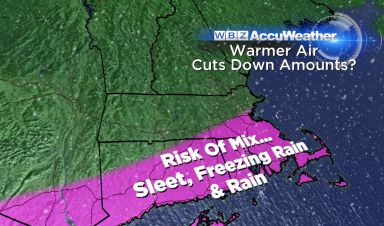
So the snow will begin Saturday with light flurries maybe accumulating an inch or two. We will get the same all day Sunday. Then Sunday night the snow will pick up in intensity. The map below from weather.com shows the pink area which will have the highest snowfall amounts. Too early to give amounts or so they say.


Another meteorologist, Dave Epstein, made a list of an approximate amount of snow that may fall. The storm is still days away so these amounts can easily change. If you add them up the range goes from 11-21 inches. I think the snow banks that are already 7 feet high may go to 10 feet.

This map below shows the predictions from two of the models that meteorologist use. This shows Boston between 13 and 19 inches of snow.


No end in sight

Some people have had it with the snow, but not me. Keep it coming! I suppose if I had to shovel I may not be so excited but I do love the snow blower. We have an inch or two of snow falling today and then we get more this weekend. Below you will find something that I copied from the WHDH channel 7 weather blog.

Long Duration Snow Ahead 
-Arctic front brings snow showers, 1-2" on Saturday midday and afternoon
-Front gets stuck just to our south, another wave of moisture adds several more inches Sunday
-Low pressure tries to develop along the front Monday, keeping the light to moderate snow going at least several more inches possible Monday
-Snow finally tapers off Tuesday morning
-Storm is all snow, and favors a fluff factor with temps in the lower teens inland to lower to mid 20s coast

Do I hear snow day? Again?


I am sure I will have a lot more to write about this weekend so check back later.

Tuesday, February 3, 2015

There is no end in sight

we have two more chances at snow within the next week. The first chance is Thursday. Right now this storm looks small. There are two storms and it looks like they will not join up. If they combined we would have significant snowfall again that would start late Thursday and go into Friday. THe way this winter is going its not out of the question.
If the two storms do not combining looks like we will only get 2 or 3 inches. The only problem is that this snow is coming in during the morning commute to make a messy ride. If anything changes and the second storm tracks further north to join the other storm I will let you know.


When this snow is over we wait for the Monday snowfall. This one could be a little bigger with maybe 6 inches. I have to watch the track of the storm. More details to come


Monday, February 2, 2015

There is more snow to come

Everyone enjoying their foot of snow today? Snow day number 3 for me this year. Who knows I may get snow day #4 tomorrow. Have to wait and see. This is not the last of the snow. Their is the potential for another significant storm Thursday night, if it doesn't go out to sea.


The we wait and watch yet another storm on Sunday. They just keep coming. I hope you like snow.
I will write with more details about Thursday when I have them.

Sunday, February 1, 2015

Update on Monday's storm (Linus)

Linus has become a more complicated storm. The track is now closer tot he coast which means some warm air will be brought in. We may be in for a period of ice and maybe a little rain. This means the snow will be the wet heavy type not light and fluffy. No fluff factor for accumulations. As a result the total snow fall amounts have been adjusted.

This is a timeline from channel 12, however all other stations agree the snow will not start until after midnight. There should be heavy snow falling for the morning commute.


These are all the updated weather maps I could find.


If anything changes I will update the blog either just before the superbowl or after the game. I will not be checking weather during the game. Go Pats!