Saturday, January 19, 2019

More Ice - Less snow

We have some changes with this storm. The amount of snow has been lowered. Instead we may get a lot of ice which is not a good thing for power outages. Here are the latest snow total maps.


This is a map I found showing the amount of ice that is expected


The ice is heavy and may cause power lines to come down so you need to be prepared for power outages. Keep your fingers crossed that doesn't happen Sunday night when the Patriots game is on.


Friday, January 18, 2019

Weekend update

Good morning everyone. I hope everyone has made plans to stay put all day Sunday. We have precipitation arriving after dark Saturday night and lasting through Sunday night. I have watched every weather forecast I could find last night and this morning in addition to reading a few articles about this storm, Harper, headed our way. This is what is supposed to happen. Snow starts Saturday night (9-10pm) then some time Sunday changes to a wintry mix and possibly to ice. The storm may change back to snow at the end. This storm will bring cod temperatures behind it so be sure to clean up your driveway before the frigid air arrives.
Below are all the snow total maps I could find this morning. I will do another update tonight if anything changes.


Thursday, January 17, 2019

Latest on Harper

Some weather stations are posting snow map totals so below I have re-posted everything I can find. Tomorrow morning I will post all the new and updated snow total maps.
Channels 4 and 5 from Boston don't have any totals just rough information


The national weather service and channel 7 WHDH have actually snow amunts


I'll be back early tomorrow morning with the latest update and hopefully a lot more information.


Harper - Our weekend storm

Just a quick update this morning. I will be back with a more in depth update tonight. The snow will start falling some time late Saturday night and continue into Sunday. We may mix with ice and possibly a little rain too.
The storm seems to have taken a track a bit south which means higher snowfall totals for us. The weather channel is the first to put out a snow total map


I am sure there will be more maps out later today so I will post whatever I can find. Check back some time early this evening for an update.
Don't forget there will be a little snowfall Friday morning too. Just an inch but the snow will probably impact the morning commute. Drive carefully


Wednesday, January 16, 2019

weekend snow

Good morning everyone, are you ready for a little snow this weekend? We start with a coating to an inch Friday morning. I know that isn't much snow but the timing isn't good as the snow will be falling during the morning commute. Drive carefully.
Then we get the bigger storm set to arrive Saturday night and last all day Sunday. Saturday night we will get snow but that should change to rain on Sunday as the storm travels inland. If the track of the storm changes then the snow amounts will change. Since this storm track continues to change everyday I guess I will continue to update this blog every day.


Monday, January 14, 2019

Martin Luther King weekend

Here is my daily update on the upcoming weekend storm. The track of the storm is critical as far as determining who gets snow and who gets rain. There is a possibility that we only 3-4 inches of snow and the rest is rain. As of this morning the storm is tracking more north giving the Norton area more rain than snow, but stay turned because that can change.

Sunday, January 13, 2019

Big Potential?

Since I blogged earlier this afternoon some new reports have come in. The snow arriving next weekend may be a little more than I first reported. The chance is there for over a foot of snow. I will have to keep an eye on this one and post reports every day this week.

Chances for snow coming soon


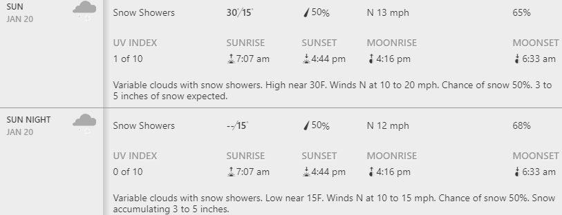
I have some good news for snow lovers out there. Its not great news, no BIG storms, but it is good meaning there is some of the white stuff coming. The first chance of snow is Sunday the 20th. Even if we get the 6-10 inches that weather.com is predicting there will not be a snow day because Monday is a holiday. What a waste of snow


Next week there are lots of chances for snow, but all small amounts.


Maybe this is a sign that winter us finally arriving. Everyone get the shovels ready and don't forget to clean the snow off your car before you drive.


You know I will continue to update this blog as I get more details about the snow. 


Friday, January 11, 2019

snow update

The last time I blogged I mentioned no accumulating snow until Sunday January 20th. Well the snow that day is only going to amount to an inch or two just like other days that week.


On Tuesday January 22nd we have a chance at getting 3 or 4 inches. Still no big storms in sight but I continue to look for one.


Tuesday, January 8, 2019

Lots of small amounts but no big storm

Winter has finally arrived - temperatures have been dropping and some flurries are in the air. We have a few chances at a little bit of white stuff over the next week. I'm sorry to report to my students that I don't see any snow days in the immediate future. There is a storm approaching us Sunday late afternoon/evening but that seems to be staying south of us so the most we would get is a few flurries.

According to weather.com the first chance we have at getting more than an inch of snow isn't until January 20th.


If the forecast changes to bring us more snow sooner then I will blog about it.