Wednesday, March 30, 2016

More Spring Snow?

Yes, there are two chances for a little snow next week. First there is a small clipper system moving west to east so we could see a dusting to an inch of snow Sunday morning. This is after we have temperatures in the high 60s this week.


The bigger threat for snow is Tuesday morning


This clipper has a little more energy and precipitation associated with it. There is the potential for up to 6 inches but we have to wait until the storm gets closer. I will be sure to keep you posted here on the weather blog

Sunday, March 20, 2016

Sunday night update

I know what is on the mind of all my students - Will we have a snow day tomorrow? It's on the minds of all the teachers too. I have read online that over 40 schools have already canceled for Monday even though the storm hasn't started and some have a delay like Southeastern Voc has a 3 hour delay. I could live with that at Norton.
Most weather stations have kept the same snow totals except these.


Channel 7 moved the 6-8 inches lower and channel 5 had 8+ inches but that is gone now.

In addition I found a snow total map from channel 10 in Providence


and the National Weather Service updated their map at 4:30 this afternoon putting Norton in the 7-8 inch range


The timing for this storm is awful for people that have to drive to work tomorrow morning


The snow will be coming down pretty heavy at 6:00 am.

As of 8:30 tonight there are two schools close to us that closed for tomorrow. They are Attleboro and Bishop Feehan. Now we wait and see if we get the call.


Snow Storm Regis

Here is your morning update...Things have stayed pretty much the same as last night. A couple of meteorologists have increased the amounts


The snow will not start until after dark and because the temperatures have been warm lately the snow will not stick to the road ways right away so driving tonight shouldn't be bad but it may be a different story by the time of the Monday morning commute.
I will blog again tonight with any late updates. Enjoy your Sunday.

Saturday, March 19, 2016

Latest on Storm Regis

So our expected snow storm has a name, Regis. Regis should be arriving after dark Sunday night and continuing through Monday morning. The timing of the heaviest snow is for the morning commute.
You may have heard earlier today that the storm was going out to sea and we would only have an inch or two. Well I didn't blog about that because I didn't believe it and now the weather people have all said the storm went back to the west so the totals are higher. Below are all the latest snow total maps.


I will blog again later tomorrow if there are any changes.


Friday, March 18, 2016

7 o'clock update

I know I said I wouldn't blog again today but the six o'clock weather reports had snow total maps so I wanted to post them.


I'll be back to blog tomorrow night.


Here is your 2:00 update. The snow is still coming our way. The track has shifted a little to the East which just means the heavy snow area has moved a little to the south. This is what was first expected


now with the small shift to the east the heaviest snow is moving southward.


Every station continues to just say the potential is there for 6+ inches. I guess we will have to wait until the storm gets closer. I will not blog again today, but I will tomorrow afternoon.

The National weather service did post a map with the expected totals by Monday morning at 7 am. Keep in mind that the snow will continue to fall until late morning so these totals may increase. this map has Norton in the region of 7 inches.


If the storm track doesn't change we should get a sizable amount of the white stuff. Please be careful if you have to shovel because the snow will be the wet heavy stuff.

Snow Day Monday?????

If this storm track does not change then we may have Monday off. Right now everything is pointing to a foot of snow Sunday night into Monday. If the storm track changes then the snow amount will change. We just have to wait until the storm is closer. The storm is still over 48 hours away. Yesterday I posted the totals that Weather channel was predicting. Today I have a snow total map from Accuweather.com and they are pretty close to the same as weather channel.


This snow is supposed to be wet and heavy so there may be some power outages. Make sure you are prepared for that. I will make sure I have flashlights, candles and that all my technology is fully charged or maybe I will go old school and read a book by candle light.

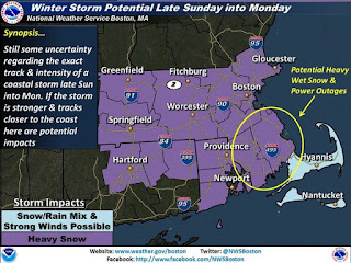
The National weather service put out this map for areas at high risk for power outages.


I will be back again this afternoon with any and all storm updates.


Thursday, March 17, 2016

Spring Snow storm

Not much new regarding this storm since I blogged this morning, except the storm is now expected to arrive a little earlier. The storm may be here by 4:00 in the afternoon. The weather channel is the only station that has posted a snow total map, so far.


as soon as I find other snow total maps I will be sure to post them.
If the storm track doesn't change we may be looking at another snow day. Stay tuned...

Spring Nor'Easter

As of today all the computer models are predicting plowable snow Sunday night into Monday. This storm will begin Friday in the southeast bringing heavy rain and then travel north to colder air bringing snow.


This is the euro model which is predicting 12 inches of snow for our area


Next is the GFS model. this shows us in the 9-11 inch range


The last model I have is the Cmc which is predicting the most. 14-16 inches.


If this storm track moves 50 miles east or west everything changes so stay tuned. I will continue to update as things change.
Just when you thought Spring had arrived, surprise its winter again!! There is snow in the forecast for Sunday night into Monday. at least 6 inches. I will investigate this and blog again when I know more.