
Monday, September 2, 2019
Dorian
I am sure you have heard there is a hurricane headed towards Florida. Hurricane Dorian is expected to make a turn to the North so I will be blogging in a day or two to let you know if we will be getting any remnants of this hurricane. Stay tuned


Sunday, March 3, 2019
Snow Day
I'm excited! I have my first snow day of the year tomorrow. Nothing has changed since my last post. The snow should begin by 10pm and will continue until 8:00 tomorrow morning. A few new maps have come out since my last post so here they are.


I hope all my students enjoy their snow day tomorrow!
I think we have a snow day
Good afternoon everyone, I do believe we will be having our first snow day of the year. Here are the latest maps. I will update again after I watch all the local news at 6pm


Saturday, March 2, 2019
Winter Storm Scott
Storm #1 for the weekend is just about over and we didn't get as big of a storm as we expected but don't worry if you love snow more is coming. Winter storm Scott is expected to arrive Sunday night after dark and continue through Monday morning. Monday morning commute may be difficult.
so drive carefully


so drive carefully

The storm has taken a slight turn further south so the rain/snow line will come not be coming to far north. Below are all the maps I can find this morning. I'm sorry I will not be able to update this later today because I am going away for the weekend to spend some time with my sisters. I will update when I get home early Sunday night.


Friday, March 1, 2019
Saturday Storm
Today is March 1st and we are expecting the biggest snowfall of the year. I guess winter starts in March. We have two storms arriving this weekend. The first is expected to arrive just after midnight tonight (early tomorrow morning) this storm should deliver over 6 inches of snow for this area. Then we have a second storm coming Sunday night. (more on that tomorrow)
The Snow Saturday will continue into early afternoon making travel difficult through the first half of the day. This graphic shows the driving conditions


The Snow Saturday will continue into early afternoon making travel difficult through the first half of the day. This graphic shows the driving conditions

I have gathered every snow map I could find and just about all of them have 6+ inches except for the National weather service. So we will start with the map having the lowest amounts.

Here are the rest of the maps that I found. If anything changes during the day I will blog again. If everything stays the same I will not be posting again today,


Enjoy the snow!
Thursday, February 28, 2019
next chance of snow
I am now keeping an eye on the weekend forecast as snow is a possibility both Saturday night and Sunday night.
these are the quotes I am finding online from meteorologists. No one is discussing the weekend storms yet.
"There is a lot of noise in the atmosphere during this time frame, but it appears the most significant storm could end up being the Sunday night one. The timing, track and precipitation type all still remain in question. Stay tuned for updates in the next 24-to-48 hours." ~ CBS
"Then, as we head into Sunday night and Monday, a quick moving storms zips through the east coast. This one will have a good slug of moisture with it, and will deliver rain/snow into southern New England. Rain/snow line too early to pin down, but where it snows, it could be significant."
~WHDH
I will post when I have more details (probably will post Friday night)
these are the quotes I am finding online from meteorologists. No one is discussing the weekend storms yet.
"There is a lot of noise in the atmosphere during this time frame, but it appears the most significant storm could end up being the Sunday night one. The timing, track and precipitation type all still remain in question. Stay tuned for updates in the next 24-to-48 hours." ~ CBS
"Then, as we head into Sunday night and Monday, a quick moving storms zips through the east coast. This one will have a good slug of moisture with it, and will deliver rain/snow into southern New England. Rain/snow line too early to pin down, but where it snows, it could be significant."
~WHDH
I will post when I have more details (probably will post Friday night)
Wednesday, February 27, 2019
Could this be our first snow day?
All my seniors are looking for a snow day and they may finally get their wish. The timing on this storm is over night into the early morning. That is perfect timing to get a snow day


Most weather station are reporting 3-6 inches of snow for us and I am sure all my students are hoping we the high end of this amount.


I will check all the weather maps again later this afternoon and I will post here if anything changes. If there isn't a new post by 4:00 this afternoon that means the snow amounts haven't changed
Monday, February 11, 2019
Update for Tuesday
Good morning everyone. Are you ready for some snow tomorrow? The snow should be starting in the early afternoon and continuing until 1:00 am when it will then change to freezing rain and eventually all rain. All signs point to a treacherous commute tomorrow afternoon.
Here are all the snow total maps I could find. They all seem to have around 3 inches for the Norton Area.


Here are all the snow total maps I could find. They all seem to have around 3 inches for the Norton Area.


I will check for new maps later this afternoon. I will post if anything changes. If I don't post again by 4:30 this afternoon, that means that nothing has changed
Sunday, February 10, 2019
Winter Storm Maya
We have some snow headed our way Tuesday afternoon. Every article I have read about this storm has the snow moving in shortly after noon time. The snow will continue for the rest of the afternoon and most of the evening. In the early morning hours, (around 2am), the snow will change over to rain which should end between 7 and 8 am.
The snow total amounts vary at this time. Below I have posted what I found online. I will look for updated snow total maps tomorrow and post those.


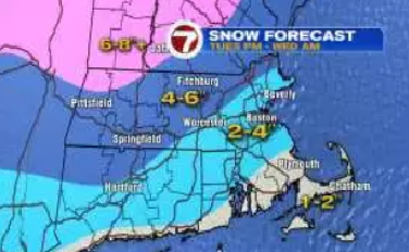

The snow total amounts vary at this time. Below I have posted what I found online. I will look for updated snow total maps tomorrow and post those.


Saturday, January 19, 2019
More Ice - Less snow
We have some changes with this storm. The amount of snow has been lowered. Instead we may get a lot of ice which is not a good thing for power outages. Here are the latest snow total maps.


This is a map I found showing the amount of ice that is expected

The ice is heavy and may cause power lines to come down so you need to be prepared for power outages. Keep your fingers crossed that doesn't happen Sunday night when the Patriots game is on.

Subscribe to:
Posts (Atom)