
Saturday, November 24, 2018
wet and windy
Wet and Windy. That is the forecast for the next 48 hours. Unfortunately the temperatures will be too warm for any snow, we will just get rain.


Sunday, November 18, 2018
A cold Thanksgiving
so sorry I missed blogging for our first snowfall of the year. I was dealing with some health issues and just couldn't get time with a computer. I hope you enjoyed what was supposed to be a dusting to an inch and turned into 6 inches.
We have some cold temperatures moving in this week. There are a couple chances for rain as well and with the colder temperatures we could get some snow flakes mixed in.

We have some cold temperatures moving in this week. There are a couple chances for rain as well and with the colder temperatures we could get some snow flakes mixed in.

Now that we have gotten our first snowfall I will try to blog every weekend to give you a preview of the week.
Tuesday, November 13, 2018
First snow of the season
Are you ready for the white stuff? Thursday night we may get a little bit of snow before it is washed away by the rain coming all day Friday


Monday, November 12, 2018
Enough Rain
Anyone else sick of all the rain we have been getting? I just would like some sunny fall days to go out and enjoy the outdoors. We have more rain coming this week too. Tuesday should be a washout and then again Thursday night into Friday. ENOUGH ALREADY!!!!
Mother nature needs to save some of this precipitation for winter so we can have some snow days.

Mother nature needs to save some of this precipitation for winter so we can have some snow days.

Sunday, October 7, 2018
Hurricane Michael?
The next storm has formed, named Michael, and now we wait to see if we get rain from this one.
The early predictions are that we get some rain at the end of the week, but hurricane tracks can be so unpredictable. I should add that this storm isn't even a hurricane yet. The National weather center does expect some strengthening in the days ahead.

The early predictions are that we get some rain at the end of the week, but hurricane tracks can be so unpredictable. I should add that this storm isn't even a hurricane yet. The National weather center does expect some strengthening in the days ahead.

Thursday, October 4, 2018
the end of summer
I don't know about anyone else, but I have a hard time saying goodbye to summer. First I have to close my pool and then days after doing that I have to return to school. Don't take that the wrong way. I do love my job but I certainly enjoy my time off. This year the warm weather is having a hard time going away and letting the fall temperatures come in. We have another warm week ahead of us.
The 3-day weekend looks great. Saturday is going to be near 80 degrees with lots of sun and then another day just like that one next Wednesday. ENJOY!

The 3-day weekend looks great. Saturday is going to be near 80 degrees with lots of sun and then another day just like that one next Wednesday. ENJOY!

Monday, September 17, 2018
Florence
Are you ready for some rain? Well we are going to get some. The remnants of Hurricane Florence are heading our way. According to the national weather service we should get a couple inches of rain.


The rain should start in the very early hours of Tuesday morning and continue into the evening. There is a flood flash warning in effect. There is also a chance of thunderstorms with strong winds so be prepared.
Sunday, September 9, 2018
It has come to my attention that people check this blog for weather updates year round not just when snow is in the forecast. That means I will have to update more often. Sorry that I disappointed my fellow teachers who were looking to me for the back to school forecast.
I have good news for this week. We will no longer have those uncomfortable hot and humid temperatures in the classroom. This week the highest temperature forecasted is 81 degrees but we will have to put up with some rain the first part of the week.


I have good news for this week. We will no longer have those uncomfortable hot and humid temperatures in the classroom. This week the highest temperature forecasted is 81 degrees but we will have to put up with some rain the first part of the week.

There is some action going on in the world of hurricanes. Right now there are 3 hurricanes in the Atlantic ocean. Florence, Helene, and Isaac. Florence is forecasted to hit the US coast Late Thursday night. I will keep an eye on that and post an update later in the week.

Wednesday, March 21, 2018
The latest on Winter Storm Toby
I'm sure all my students are patiently waiting for this update wondering if they are going to have snow day #7 tomorrow. Well I will give you all the information I have found and then you decide.

First the timing: The snow may start around 11:00 am in our area but this will be light snow and will not stick to the road at the beginning. By 7pm the snow will start to get heavier and the steady snow will continue through early Thursday morning. I am now hearing that the snow may linger until 7 am Thursday.
Winds: we will be getting higher than usual winds in our area. so by now we all know that with heavy wet snow and high winds there is the chance of power outages. I will be prepared with flashlights, candles, lots of blankets, and a fully charged cell phone.
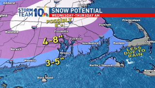
Snow amounts: Here are some of the maps that I found this morning.


according to these maps wbz, fox, and NBC all predict this area in the 8-12 inch range and the rest predict up to 8 inches. Even 6 inches of this wet heavy snow can cause problems.

First the timing: The snow may start around 11:00 am in our area but this will be light snow and will not stick to the road at the beginning. By 7pm the snow will start to get heavier and the steady snow will continue through early Thursday morning. I am now hearing that the snow may linger until 7 am Thursday.
Winds: we will be getting higher than usual winds in our area. so by now we all know that with heavy wet snow and high winds there is the chance of power outages. I will be prepared with flashlights, candles, lots of blankets, and a fully charged cell phone.
Snow amounts: Here are some of the maps that I found this morning.


according to these maps wbz, fox, and NBC all predict this area in the 8-12 inch range and the rest predict up to 8 inches. Even 6 inches of this wet heavy snow can cause problems.
Tuesday, March 20, 2018
Toby is our next nor'easter
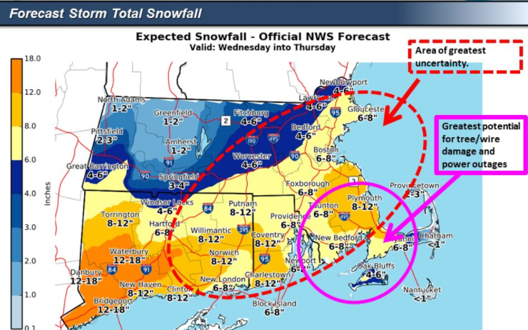
Winter storm Toby is due to arrive here Wednesday morning. There has been a little change in the track of the storm. Toby has gone a little further south so amounts are a little bit lower. We still need to be concerned with the winds and the fact that this snow is supposed to be heavy wet snow. Be prepared for more power outages.
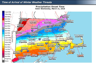
The snow will start to fall some time in the late morning, but will be light and should not accumulate much during the day. According to everything I have read today the heaviest snow should fall between 5pm Wednesday and 5am Thursday. Below is a map from the national weather service with expected times of the snow arriving.
The winter storm warning has been expanded to include the cape.




The snow will start to fall some time in the late morning, but will be light and should not accumulate much during the day. According to everything I have read today the heaviest snow should fall between 5pm Wednesday and 5am Thursday. Below is a map from the national weather service with expected times of the snow arriving.

The winter storm warning has been expanded to include the cape.

Here are the latest snowfall maps with the lower totals


I will be back tomorrow morning with another update unless things change dramatically in the next 6 hours, if they do then I will post again tonight.
Subscribe to:
Posts (Atom)