Nothing has changed in Fridays forecast but I did find two more snow total maps so I wanted to post those.


I will collect more data Thursday morning and post some time before noon
Nothing has changed in Fridays forecast but I did find two more snow total maps so I wanted to post those.
Good morning to all my fellow snow lovers out there. You should expect snow to start falling before you wake up Friday morning, That snow will continue for most of the daylight hours. I have read, online, as much as I can about this upcoming storm, but the storm is just developing on the west coast so there is quite a ways to travel still before it gets to Massachusetts. That means that a lot can change.
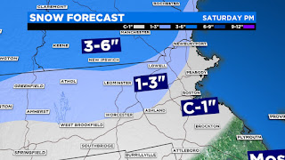
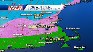
As of right now these maps show what is expected in terms of total snow fall. I will continue to search online for updates throughout the day and will update later tonight or tomorrow morning if things change.


The low that is going to produce our storm Friday hasn’t developed yet. That means that making snowfall predictions is a little difficult right now. Once the low forms, everyone will be following the track to see if we get all snow or some rain mixing in. I will post at least once everyday to keep you updated. Here is the first snowfall amount that I found online

Check in tomorrow for more details.
There are two chances for snow this week, but both days we will only see an inch or two.
Monday snow will start in the afternoon and continue through the early evening hours. All light precip and not amounting to much in our area but more on the cape. Here are the maps from channels 4 and 5


Friday there is another chance for an inch or two

This is the headline from the weather channel
"Winter Storm Carrie is forecast to bring snow to New England this weekend."
The further North you live the more snow you will get. My area is only expecting a dusting to an inch.
The snow should start late afternoon and continue through the night. If you have shopping to do, get out there now.
Here are a few snow maps that I found online


We may be catching a break with this storm. The hurricane center has moved the storm track a little to the west so the storm will be making a direct hit to Long Island and Connecticut. But we will still be feeling some effects.


Today we are getting lots of rain thanks to Hurricane Fred and Sunday we may be getting a visit from hurricane Henri. I will closely monitor this situation and post more about Henri either later today or tomorrow. Stay tuned.


March usually brings us some snow so even though we had 60 degree temperatures last week, we are getting a couple inches of snow overnight.
Precip will start as rain later tonight and then change to snow in the early morning hours. Here are a few snow total maps that I found.


